Peak 7100 Loop
![/galleries/cedars_2011/001_the_east_fork_pour-off_[Sun_Apr_17_11:37:10_MDT_2011].thumbnail.jpg](../galleries/cedars_2011/001_the_east_fork_pour-off_%5BSun_Apr_17_11:37:10_MDT_2011%5D.jpg)
Getting There
I was looking at topo maps and Google satellite views for the Cedars a few years ago, and I noticed some canyons north and west of the Cedars' high point that looked like they had potential. I organized a WMC trip to the area and it turned out to be a fun little hike, with cliffy canyons and pour-offs to work around, and some nice views from the crest.
To get to the start of the hike, drive to the start of the west-side road as described in the overall Cedars page. According to Google Maps, it's about 11.8 mi south on this road to the place where you want to park. The road jogs to the east here to get through the wash that you'll hike in. If you reach Quincy Spring (where a fairly obvious road heads up into the canyon), you've gone too far. My GPS reading at the parking spot is UTM 0330409 4493846.
The road is generally in good shape, but on a couple of recent occasions, I have encountered some deep ruts / washouts that cut across the road. The road can also be muddy and slick in the spring, and even when it's dry, if some idiot drove on the road when it was really, really soft, you may end up dealing with the ruts they created. The road does seem to get bladed yearly in the spring.
There are the usual cows, horses and pronghorn to be seen along the road. Make sure that you don't run into one.
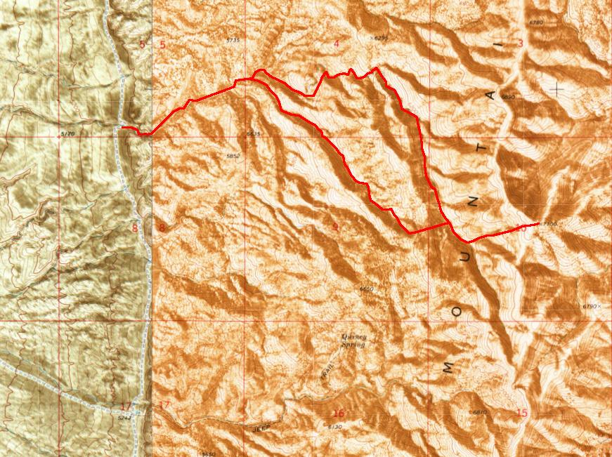
The Route
![/galleries/cedars_2011/000_the_red_shale_hill_[Sun_Apr_17_11:27:39_MDT_2011].thumbnail.jpg](../galleries/cedars_2011/000_the_red_shale_hill_%5BSun_Apr_17_11:27:39_MDT_2011%5D.jpg)
From the intersection of the road and the wash, head east up the wash bottom. The wash deepens a bit, but it isn't particularly interesting the lowest part.
After a mile or so, the valley opens up. You can see some colorful shale slopes to the north, as shown in the photo. Stay in the main fork of the wash, avoiding the large tributary that comes in from the southeast (right) and the smaller draw to the north (left) that comes down from the shale area.
![/galleries/cedars_2011/002_getting_past_the_pour-off_[Sun_Apr_17_11:42:14_MDT_2011].thumbnail.jpg](../galleries/cedars_2011/002_getting_past_the_pour-off_%5BSun_Apr_17_11:42:14_MDT_2011%5D.jpg)
Stanley Chiang
The wash bends to the southeast and gets deeper. The walls become cliffier, with blocky towers. Eventually you reach a substantial cliff band with a pour-off. The photo at the top of this page shows the pour-off from below — it's a very pretty spot.
To get around the pour-off, work your way from left to right up a series of blocky ledges, as seen in this photo. Watch out for loose blocks and for mud. With a little route-finding, you should be able to make it past the cliff band fairly easily.
From here, the wash makes a sharp bend to the north (left) for a couple hundred yards. You can either return to the wash bottom (where there are more cliffs), or you can climb over a nose and cut off a bend where the wash goes eastward again. If you do this, check a map or GPS to make sure that you are still on track.
![/galleries/cedars_2011/003_the_upper_wash_[Sun_Apr_17_12:00:19_MDT_2011].thumbnail.jpg](../galleries/cedars_2011/003_the_upper_wash_%5BSun_Apr_17_12:00:19_MDT_2011%5D.jpg)
The wash heads generally east and enters another section where the walls are low but cliffy. A wash enters from the south over a pour-off; skip this wash and turn south (right) at the next fork in a hundred yards. This fork is deeper and has many turrets on its cliffs, as well as some sizable solution cavities and a couple of small arches. You enter a fire-scarred area with grass and rock slabs as a floor; it's a very pretty section.
![/galleries/cedars_2011/004_a_pour-off_in_the_upper_wash_[Sun_Apr_17_12:34:46_MDT_2011].thumbnail.jpg](../galleries/cedars_2011/004_a_pour-off_in_the_upper_wash_%5BSun_Apr_17_12:34:46_MDT_2011%5D.jpg)
Another cliff band produces another set of pour-offs, as seen in this photo. You can get around the pour-offs on the east (left) side, on the right side of the photo. After you pass through these cliffs, you can drop back down into the wash.
![/galleries/cedars_2011/005_heading_down_from_Peak_7100_[Sun_Apr_17_13:45:31_MDT_2011].thumbnail.jpg](../galleries/cedars_2011/005_heading_down_from_Peak_7100_%5BSun_Apr_17_13:45:31_MDT_2011%5D.jpg)
Above the pour-offs, the cliffs gradually fall away. Keep an eye out for a substantial draw that comes down from the south (right). At that landmark, you can head up the slopes to the east (left) to reach the crest. It's moderately steep, but it's very open. Peak 7100 is the high point in this stretch, and it is a short distance to the south once you're on top. You can walk up the wash a little bit before ascending if you want to go directly at the summit.
The top is pretty bare, as seen in the photo. There are big views to the west across the salt flats to Pilot Peak and the Silver Island Range.
![/galleries/cedars_2011/006_fire_traces_[Sun_Apr_17_14:19:46_MDT_2011].thumbnail.jpg](../galleries/cedars_2011/006_fire_traces_%5BSun_Apr_17_14:19:46_MDT_2011%5D.jpg)
Retrace your steps to the bottom of the wash, and find that south-oriented draw again. Walk up the draw a hundred yards or so, then turn directly west and hike up to the ridgeline. You should see a bowl that opens to the northwest.
When we were here in 2011, not only was the fire scar quite raw, we could also see the pink remains of fire retardant drops.
![/galleries/cedars_2011/007_the_west_fork_pour-off_[Sun_Apr_17_14:54:01_MDT_2011].thumbnail.jpg](../galleries/cedars_2011/007_the_west_fork_pour-off_%5BSun_Apr_17_14:54:01_MDT_2011%5D.jpg)
Mark Bloomenthal
Head northwest down the wash. The wash seems pretty innocent until it makes an odd dodge to the east (right) and enters a gorge. There is an impassable pour-off in the gorge, but it's fun to explore.
To get around the obstacle, go straight where the wash goes right, and climb up over a hump and down the backside into the wash. From here, you can walk back up to the pour-off, as seen in the photo.
When you're finished, you can stroll down the wash to the junction with the main fork, then turn west (left) and walk back to your car.
I suppose that you could do this loop counter-clockwise, but I think it's more fun when run clockwise.