Vermillion Castle
![/galleries/cedar_breaks_2014/000_turrets_on_the_castle_[Sun_Jul_6_12:04:32_MDT_2014].thumbnail.jpg](../galleries/cedar_breaks_2014/000_turrets_on_the_castle_[Sun_Jul_6_12:04:32_MDT_2014].thumbnail.jpg)
Getting There
Yes, it's really spelled Vermillion. This is a fairly short hike, with some really nice scenery.
Parowan Canyon isn't in a park, but nonetheless it has some of the coolest scenery in the area. It has pink and red cliffs, towers and hoodoos out the wazoo. The higher elevations have thick forest, meadows and basalt cliffs.
I first visited the area in the mid-80's. I stayed at (what was then) the Vermillion Castle Campground, which I thought was a gorgeous location. I remember that I managed to back up my VW Beetle and go off the side of a cattle guard; three friends and I were able to lift the little car back up out of the ditch.
The campground was washed out repeatedly in the 80s, and the Forest Service no longer wants people to camp there because of the danger. The campsites and tables are still there, but this spot is now called the Parowan Five-Mile Picnic Area. The Vermillion Castle trailhead is 200 yards up the road from the picnic area on the north (left) side.
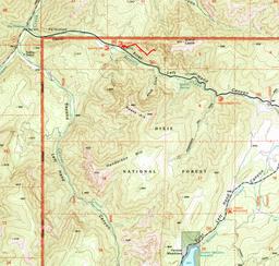
To get there, drive to Parowan on I-15 and get off at exit 78 (the north end of town) or exit 75 (the south end). Drive south or east (respectively) into Parowan and follow the signs for SR-143 east to Brian Head. From the intersection of Center St and Main St, it's about 3.3 mi east and south on SR-143 to the Bowery Canyon road, signed to the Five-Mile Picnic Area and Yankee Meadows. Go east (left) on this (paved) road about 1.4 mi. Look for the Vermillion Castle trailhead sign and a small parking area on the north (left). (All driving distances here are from Google Maps.) I don't have a GPS waypoint for the trailhead, but it appears to be at roughly UTM 0342300 4184300.
The Route
The trail starts out in scrub oak and juniper, and switchbacks up a steep hillside. It works its way up into an area of gray conglomerate towers, and threads through some cliffy spots up onto a bench.
The trail runs east between the red cliffs above and the gray cliffs below, going up and down through open pinyon / ponderosa / juniper woodland. The view south (right) toward Noah's Ark is really nice.
After a while, the trail climbs a bit and gets closer to the red cliffs. Lots of cliffs resemble castle walls in Southern Utah, and these cliffs earn the description too.
The trail runs a little further than is marked on the map. It ends up at the foot of some buff-colored cliffs below banded vermilion turrets. There are some young ponderosa pines surrounding an open area that's more than suitable as a lunch spot.
The view up-canyon is pretty swell. The pavement does not go all the way to Yankee Meadows, but it does reach the upper basin.
![/galleries/cedar_breaks_2014/001_conglomerate_crags_at_the_foot_of_the_castle_[Sun_Jul_6_11:54:01_MDT_2014].thumbnail.jpg](../galleries/cedar_breaks_2014/001_conglomerate_crags_at_the_foot_of_the_castle_[Sun_Jul_6_11:54:01_MDT_2014].thumbnail.jpg)
![/galleries/cedar_breaks_2014/002_the_bench_[Sun_Jul_6_12:00:32_MDT_2014].thumbnail.jpg](../galleries/cedar_breaks_2014/002_the_bench_[Sun_Jul_6_12:00:32_MDT_2014].thumbnail.jpg)
![/galleries/cedar_breaks_2014/003_battlements_[Sun_Jul_6_12:02:25_MDT_2014].thumbnail.jpg](../galleries/cedar_breaks_2014/003_battlements_[Sun_Jul_6_12:02:25_MDT_2014].thumbnail.jpg)
![/galleries/cedar_breaks_2014/004_ponderosa_grove_in_the_shadow_of_the_walls_[Sun_Jul_6_12:05:03_MDT_2014].thumbnail.jpg](../galleries/cedar_breaks_2014/004_ponderosa_grove_in_the_shadow_of_the_walls_[Sun_Jul_6_12:05:03_MDT_2014].thumbnail.jpg)
![/galleries/cedar_breaks_2014/005_Bowery_Canyon_view_[Sun_Jul_6_12:05:51_MDT_2014].thumbnail.jpg](../galleries/cedar_breaks_2014/005_Bowery_Canyon_view_[Sun_Jul_6_12:05:51_MDT_2014].thumbnail.jpg)
