Moab in December of 1999
Highlights: Delicate Arch, Grand View Point, and the Colorado River
Click on any picture to see a larger one.
Day 1
Getting to Moab. It was an unusually warm Winter day, which provided a sunny path
to Moab instead of the dreary, wet one I was expecting. Once there I quickly went
into Arches National Park, which is just north of Moab. My goal was simple: photograph
the Delicate Arch, which is world famous and appears on Utah license plates. I cruise up
and down the road until there was a turn off to the right and the sign that said Delicate Arch.
I pulled into the parking lot at the trailhead thinking that it will be a breeze to get to arch
and go about my business of capturing it on film. The mile and half trail was a bit more
challenging than I had bargained for. While it starts out relatively flat it quickly gets
steeper and you begin ascending the familiar golden-red slick rock sandstone of the area.
This takes a lot of one as I learned and I paused a couple of times to catch my breath.
I had brought water and an apple with me, but those would have to wait for later. I still
had a long distance to go. I finally get towards the top on a reclining ramp that was carved
out by someone some years ago and there it is -- the Delicate Arch.
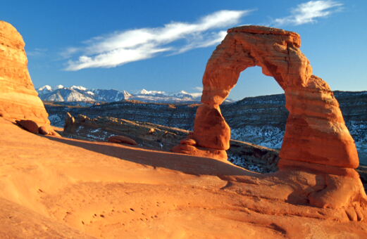
I looked for a good vantage point and took a few shots. I then knew that I had to find a permanent spot and
stake my claim to my spot before the sunset. I slid down off a rock and planted myself.
I had come almost too early -- the sun was not due to go down for another hour and
fifteen minutes. I ate my apple and basked in the sunlight relaxing as I breathed the cool
desert air. Tourists from all over were around. A few from Taiwan came through while
there was another group from Germany and some from France. Time passed and then with
about 10 or 15 minutes to go myself with three others started taking pictures wildly
trying to take full advantage of the angle of the sun, the La Sal mountains and the
clouds to frame the "perfect" picture. I think I got it, but you be the judge. A few minutes
later the sun was down and the place grew dark quickly. Everyone scurried down the trail
towards the parking lot before it became too dark.
Day 2
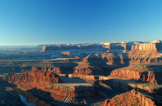
The purpose today was to get a picture at sunrise at Dead Horse Point State Park and
explore Canyonlands. There was a slight wind which quickly brought down the temperature
as I drove in the dark in the morning. I had thought that Dead Horse Point State Park was some 45 miles
from Moab, however it was about 30, so I arrived well ahead of the sunrise. The park is
rather small, but it has a fantastic view point. The built up view point with metal railing
did not provide the angle I was looking for. I looked around and found a place upon a large
rock. I stood and paced in the coldness of the morning. The horizon was turning from black, to
a dark purple, to a dark blue with a tint of deep orange on the edge of the horizon.. It was a fantastic transformation. As the sunrise came closer I still thought that there might be a better place so I moved down further and had get down on another outcropping of rocks and carefully place my tripod and camera near the edge. Not too close though. The drop is several hundred feet and I was literally alone. No one else was in the park save a couple of rangers, but I think they were having breakfast as I had to put the park fee ($5) into an envelope and depositing in a steel post.
There was an eerie silence to the place. All I heard was the wind and some distance humming of
some equipment in the far distance. I checked my equipment and made ready for the time when
there would be enough light. Finally the sun came up enough to provide some great light as it
came from the left of the scene and I think I captured the moment.
A polarizer filter provided some relief to the haze and the angle of the sun. I shot a roll
and then tried some different lenses and different compositions.
As the sunrise period came and went I realized that the lighting was not going to
get any better, so I packed up the equipment and strapped on the tripod to the
backpack and went back to the parking lot. My car was the lone ranger of sorts as
there were no others when I left. I exited the park and the long road to it back to
the main road and took a left with an eye on Canyonlands National Park.
After a few miles I finally came to the entrance. I came up to the little booth that
you pay your fee at and it was not manned this morning. I looked at the time again
and realized it was past 9:00 AM, so I was not too early. I go in and stop at the visitors
center. I attempt to pay my fee, but I am told that during that time of the year no fee
was collected. This was unusual, but I wasn't going to argue with the park ranger. I asked where
White Rim outlook and Grand View outlook were located.
The ranger quickly highlighted
the map where I could find these and I went on my way. I decided to just go to the Grand
View and see if anything else struck my interest. The portion of the park that I was in was in
the Island in the Sky district, which is the northern most part of Canyonlands National Park.
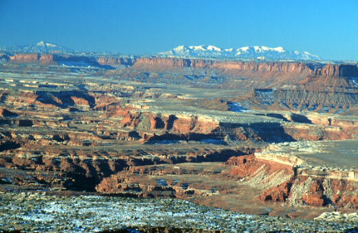
At the end of this section of the park is the Grand View. Finding it was relatively easy --
keep on heading south until there is no more road. Once there you hike about a mile
to a fantastic outlook. The trail was relatively easy going being mostly flat, however I
left my car in such a hurry I forgot to throw in a bottle of water into the pack and I was
sure sorry for that -- not so much for quenching my thirst, but to relieve myself of a
bad case of cotton mouth. The trail ends abruptly, but the view of the formations in
the distance are fantastic and the views along the way were great as well. The trail
is marked with a series of rock piles called cairns that mark the boundaries of
where you should be within. Once again I had the park to myself. A fellow was leaving
just as I arrived and so I appreciated the solitude. I remember from yesterday someone hollering
loudly from below when I was up at Delicate Arch and I
prefer the quietness of the moment over some idiot bellowing at the top of his lungs.
I continued exploring Canyonlands, but I looked about for some views, but I did not
find anything that really matched the views of Grand View so I headed back to Moab
for some lunch.
After lunch I headed out of town and onto scenic Route 128, which runs adjacent to
the Colorado River. The drive is fantastic and offers some great views. I was in
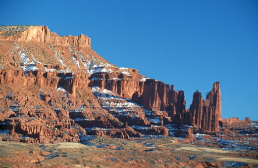
search of something called Fisher Towers and I found it, but I did not want to get
pictures up close as some of the grandeur of the dark red stone could only be
appreciated from a distance. I doubled back on the road and remembered seeing
a great view point on the way out. I came back to the place and grabbed my gear
and climbed a nearby hill that offered a great vantage point to the scenery. I was
disappointed in the presence of too many shadows, but due to the angle of the sun
in Winter and the location of the towers I did not have much choice so I took
some shots anyway. The Fisher Towers are the rock formation to the most right of the picture.
Going back and forth the bridge over the Colorado River I had noticed the
reflective quality of the slow moving water in portions of the river and wondered
if I could take advantage of that. I looked around a bit, but was not satisfied once
I got to the river's edge, so I headed onto the Fisher Towers as described above.
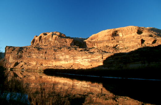
On the way back to Moab it was getting late in the afternoon and the sun was only
an hour from setting and made some great patterns reflecting in the river. I saw ahead of
me some possibilities and so I quickly pulled over and burned an entire roll just off the
side of the road looking for the best angle. I think I found it. The vegetation of the edge
with the reflecting water in the middle and the red stone in the background made a
great combination.
Day 3
My goal on this day was to return to Arches National Park and go to the Devil's Garden, which
is a series of trails at the end of the park that showcases a variety of arches. The morning wind
was unusually cold this morning and there was more snow than I had expected. The snow crunched beneath my feet as I went down the trail. I came to the tunnel arch and then the pine tree arch. Neither
of these were particularly impressive, so I continued on and then saw landscape arch. Now
this was impressive. Instead of taking the usual route I veered off the trail onto the Primitive
Loop Trail, which adds a couple of hours to the whole trip, but well worth it. It seemed a lot
longer than it really was, but that was probably because I was sweating profusely with my
coat, sweatshirt and thermals. The trail was very demanding at points requiring some jumping,
leaping and lifting of one self up and over rocks. There is one arch on the Primitive loop that
is called Private arch, however it was kind of small and not that impressive. At the end of
the primitive trail it links up with the main trail and you can head off to Angel arch or continue
onto the Double O arch. I chose to stay on the main trail and took a few shots of the Double
O arch. From here you go over a rock formation called a fin because it is a very long and
narrow piece of sandstone that you must traverse to continue. Once past this you can
see two other arches, which I skipped having spent most of my strength on the primitive portion
of the trail. As you descend the hills you came across wall arch, which is located between
two other portions of rock. I thought of taking a picture, but it was difficult to get an
angle that could capture the whole arch, so I moved on and was back to landscape arch.
I had remembered that a better view of the arch came from the primitive trail, so I went back
on the primitive trail for a few clicks and then found the spot I was some 3 hours previously.
I was limping now and still have another mile plus back to the parking lot. It was a pain, but
I made it back only to see some guys in shorts and thongs starting on the trail.
Neither of these are good clothing for snow, ice, and temperatures in the high 30s that
the trail ahead demanded, but I suppose they would find that out in about the first part of
the trail which is in the shade with some wicked winds blowing down on you as you go
through a opening between two huge rock formations.
All in all it was a memorable experience.
|