Hastings Pass
![/galleries/cedars_1987/002_the_crest_looking_south_[Sat_Oct_17_1987].thumbnail.jpg](../galleries/cedars_1987/002_the_crest_looking_south_[Sat_Oct_17_1987].thumbnail.jpg)
Getting There
The Donner Party crossed Hastings Pass in the northern Cedar Mountains on Thursday, September 3rd, 1846. They were following the path of the guide Lansford W Hastings, who had sold them on a route west across the Bonneville Salt Flats rather than the standard route to the north. Traveling ahead with another group of settlers, Hastings had left a note at Hope Wells in Skull Valley explaining that it would take two days and two nights of continuous travel to reach the springs at Pilot Peak on the west side of the salt flats.
In the end, it took the Donner Party six days to cover the distance from Hope Wells, losing many oxen and a number of wagons in the process. The spring on Pilot Peak is now called Donner Springs.
The pass is somewhat innocuous, but it has some nice views, and you can easily ramble along the crest of the range south from the pass for a number of miles. The scenery is pleasant but not spectacular, with broad vistas to the salt flats in the west and the salt marshes of northern Skull Valley to the east. Hastings presumably chose to cross at Hastings Pass rather than further north where I-80 runs because the route had to dip south to avoid the marshes, and going north again on the west side of the marshes to the lower northern pass would have added considerable distance.
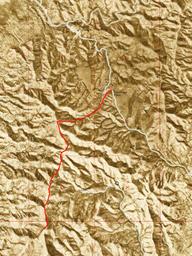
The road to Hastings Pass is pretty good on both sides, but it's probably faster (again) to reach the pass from the west side. From the intersection with the west side dirt road described in the main Cedar Mountains page, go east (straight). At a junction just below the aragonite mine in the lower part of the canyon, stay southeast (right) on the better road. It's fun to stop at the mine and check out the piles of pretty aragonite. On my last visit, it looked like someone had revived the mine, so be courteous and don't disturb the site. There are some sinkholes along the aragonite vein — take care not to fall in.
The road makes a switchback just before the pass. There apparently is a big BLM sign at the pass now. Park there.
The Route
A reasonable destination for a 5 mi r/t hike is Peak 6612. From the pass, head south on a track into a wash. Follow the track until it peters out, then keep following the wash as it bends to the west. Climb south out of the wash onto a small ridge, then go west up the ridge to the summit.
From here, you can head south along the ridgeline, with several ups and downs. Peak 6612 is the highest bump in the immediate area.
The photo shows a view to the southeast across Skull Valley to Deseret Peak (tucked in the clouds), with the Skull Valley Indian Reservation and Iosepa on the bench below.
This photo shows the view northeast across the marshy outlet of Skull Valley, then an arm of the Great Salt Lake, then Stansbury Island and finally, in the very far distance, the Wasatch Range.
This section of the crest isn't very craggy, but there are a few pretty cliffy spots here and there.
![/galleries/cedars_1987/000_a_view_across_Skull_Valley_[Sat_Oct_17_1987].thumbnail.jpg](../galleries/cedars_1987/000_a_view_across_Skull_Valley_[Sat_Oct_17_1987].thumbnail.jpg)
![/galleries/cedars_1987/001_a_view_toward_Stansbury_Island_[Sat_Oct_17_1987].thumbnail.jpg](../galleries/cedars_1987/001_a_view_toward_Stansbury_Island_[Sat_Oct_17_1987].thumbnail.jpg)
![/galleries/cedars_1987/003_cliffs_and_mist_[Sat_Oct_17_1987].thumbnail.jpg](../galleries/cedars_1987/003_cliffs_and_mist_[Sat_Oct_17_1987].thumbnail.jpg)
