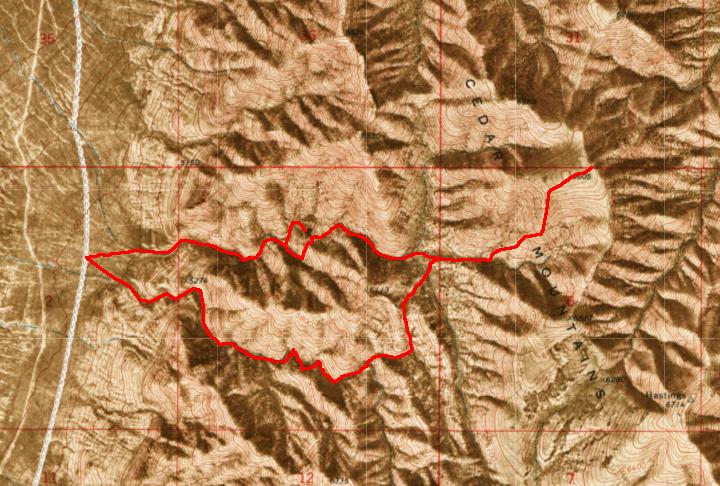
North Cedars Loop
![/galleries/cedars_2004/001_the_wall_[Sun_Apr_04_2004].thumbnail.jpg](../galleries/cedars_2004/001_the_wall_[Sun_Apr_04_2004].jpg)
Getting There
I like to do this hike because it has all of the classic Cedars highlights — the unexpected topography, the views, a little scrambling. It's also relatively easy to reach the start of this hike by car.
Follow the directions in the parent page to get to the junction with the main west side Cedars road. Rather than turning here, go straight east toward the mountains for about 0.7 mi. Shortly before reaching the foothills, a side road turns north (left); follow this road along the base of the range for about 2.4 miles. The start of the hike is at a rise in the road where the alluvial fans from two closely adjacent drainages come together. My GPS waypoint for this spot shows UTM 0336289 4513836.
The road is usually in pretty good shape, but watch out for ruts and rocks. Also watch out when parking to make sure that you don't smack a rock when you pull off of the road. And also watch out for cows, which often stray into the road. With all of this watching, you may get lucky and spot some pronghorn or wild horses.
The Route
![/galleries/cedars_2004/000_the_big_pour-off_[Sun_Apr_04_2004].thumbnail.jpg](../galleries/cedars_2004/000_the_big_pour-off_[Sun_Apr_04_2004].jpg)
Walk through the weeds over to the northern (left) of the two washes to your east. The walls of the wash gradually become taller and cliffier as it zigs and zags generally eastward.
The route suddenly ends at a massive limestone pour-off. This is a fine spot to get everyone organized for the next step, which involves some route-finding.
![/galleries/cedars_2004/002_to_the_top_of_the_pour-off_[Sun_Apr_04_2004].thumbnail.jpg](../galleries/cedars_2004/002_to_the_top_of_the_pour-off_[Sun_Apr_04_2004].jpg)
To get above the pour-off, you need to backtrack west and then south along the bottom of the wash about 120 yards. Look up to the southeast (left), where a small draw comes down to meet the wash where it bends to the west. A fault line runs through the cliff band at the head of this draw, providing a steep but walkable route to the top.
Once above the wall, contour northward (left) to the pour-off. You will climb a bit, then drop into the main drainage again above the pour-off. It's worth the side trip down to the little gorge at the top of the pour-off (as seen in the photo).
From here, head upstream to the east (right). After a few bends, the wash enters a surprisingly wide upland basin, with sagebrush and scattered junipers.
Peak 6605 to the northeast makes a nice destination with a view. Cross the basin to the east (straight), following a fork of the drainage. There is a fair amount of deadfall, but you can usually pick up cow paths or game trails that get through the worst of it. Look out for cactus where you least expect it.
At a major fork in the drainage, get out of the wash and head east (straight) and then north (left) up the ridge between the forks. It's moderately steep, with some loose rock and brush. The going is slightly better toward the east side of the ridge, but in general it's best to stay near the midline. Follow the ridge north to a meadowy plateau. There are pleasant lunch spots on the east side of the plateau, with views down to Skull Valley and the Great Salt Lake.
![/galleries/cedars_2004/003_looking_back_at_the_route_[Sun_Apr_04_2004].thumbnail.jpg](../galleries/cedars_2004/003_looking_back_at_the_route_[Sun_Apr_04_2004].jpg)
This photo shows the view off to the salt flats to the west. You can see at the left where the wash enters the upper basin. The ascent route is off to the left of the photo.
![/galleries/cedars_2004/004_coming_down_from_the_top_[Sun_Apr_04_2004].thumbnail.jpg](../galleries/cedars_2004/004_coming_down_from_the_top_[Sun_Apr_04_2004].jpg)
Head back down to the upper basin, following the same route that you took coming up. This photo shows some of the sandy limestone on the ridge coming down from Peak 6605. Watch out for loose blocks and slabs.
![/galleries/cedars_2004/005_twin_mini-pour-offs_[Sun_Apr_04_2004].thumbnail.jpg](../galleries/cedars_2004/005_twin_mini-pour-offs_[Sun_Apr_04_2004].jpg)
When you reach the basin, about 200 yards before the confluence of the basin's drainages, cut to the southwest (left) into the southernmost drainage. You should see a green grassy draw that comes down to the drainage from the southwest; if you turned at the right place, then this draw will be right in front of you when you reach the main wash. Head up this draw. Bear south (left) at a fork; you should be able to pick up a game trail in this section. After a few minutes, you will reach a saddle. This is the divide with the wash that comes out just to the south of the wash that you went up.
Head down into the wash, which trends westward (right-ish) through juniper trees and sagebrush. There are a few places that require you to step up onto the slope to avoid deadfall or live trees in the wash.
The walls of the wash gradually rise, and you start to encounter cliff bands that produce pour-offs in the wash, like the one in the photo.
![/galleries/cedars_2004/006_steps_[Sun_Apr_04_2004].thumbnail.jpg](../galleries/cedars_2004/006_steps_[Sun_Apr_04_2004].jpg)
Alex Rudd
A couple of the pour-offs are basically impassable. However, you can walk along either the south rim (easier) or the north rim (harder) and find a non-technical route down. If you feel like a challenge, you can try to descend the pour-offs, but be aware that the rock is brittle and sharp, except for a few spots in the dead center, where it is slick and polished.
More often, the pour-offs are an easy scramble, like this one.
When you finally walk out of the bottom end of the wash, you should see your car(s) immediately to the west.
I have done a number of variations on this route, but the version described above hits the best parts.
There are a few other summits around the upper basin that look interesting, particularly the crag that is just north of the drainage junction.