Tabby's Peak
![/galleries/cedars_1987/005_Lincoln_logs_[Sat_Oct_10_1987].thumbnail.jpg](../galleries/cedars_1987/005_Lincoln_logs_[Sat_Oct_10_1987].jpg)
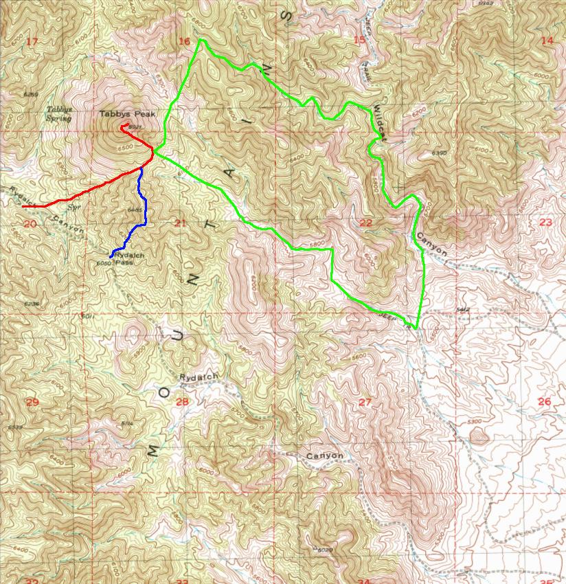
Getting There
Tabby's Peak is a summit in the southern part of the Cedars that has a columnar basalt flow on top. It's a fun little hike in the spring or fall. The peak may be named after the Ute chief Tabby (Taíwi).
I have been up Tabby's Peak a number of times, using a different route pretty much every time. I have marked the most straightforward route on the map in red, with an alternate route from Rydalch Pass in blue and an extended loop hike through Wildcat Canyon in green. The alternate routes follow the red route to the summit where they join together.
When I started doing Tabby's Peak, I generally got there from the east side. I don't recommend this route now because the last time the I drove it (2003), it was buried in a thick layer of soft dust that caused problems even for my 4WD Toyota 4Runner. If you want to give it a shot, here are directions via Google Maps. Get off I-80 at the Dugway exit, exit 77 to SR-196. Go south about 17 mi and look for some irrigated fields on the west side of the highway, just after the highway bends to the left. At the south end of these fields, there is an unsigned dirt road with a cattle guard, heading west (right).
Go west (right) on the dirt road about 0.8 mi, then turn southwest (left) on a road that cuts diagonally across the valley. Stay on the better road at each intersection and continue southwest. The road will eventually go up Rydalch Canyon; Rydalch Pass is about 15.5 mi from the turn. If you get into deep dust, make sure that your 4WD is engaged, roll up your windows and don't stop. I ended up driving with one set of wheels up on the edge of the roadway where the dust and the ruts were shallower.
The recommended route is to go down the west side. From the intersection of the west side Cedars road with the Hastings Pass road, go south about 22.5 mi. The road starts out in good condition but deteriorates, so take care with your driving. Eventually the road curves southeast into Rydalch Canyon (yes, both the east and west approaches to Rydalch Pass are called Rydalch Canyon). Look for a dome-shaped peak to the north (left) with a cap of black lava and fields of lava boulders on its flanks — that's Tabby's Peak. The most straightforward approach is to go northeast up a draw that leads to a saddle between Tabby's and the next bump to the south; park where this draw meets the main wash in Rydalch Canyon, next to the road. An alternative is to park at Rydalch Pass and climb north (left) over the bump to get to the saddle.
The distances here are derived from Google Maps, rather than from an odometer. I don't have a GPS reading for the start of the red-marked route, but on the USGS map it appears to be located at approximately UTM 0330835 4480165.
The Route
![/galleries/cedars_1987/007_black_snowfield_[Sat_Oct_10_1987].thumbnail.jpg](../galleries/cedars_1987/007_black_snowfield_[Sat_Oct_10_1987].jpg)
The peak is guarded on the south, west and northwest by piles of black lava boulders that are misery to slog through. The trick is to work your way up to the pass while staying below the rockpiles. There is a fair amount of mountain-mahogany brush and deadfall to navigate before you get to the saddle.
![/galleries/cedars_2003/002_castle_turret_[Sun_Oct_12_2003].thumbnail.jpg](../galleries/cedars_2003/002_castle_turret_[Sun_Oct_12_2003].jpg)
Once at the saddle, you'll see the other problem. The peak is too steep to ascend on the northern side — this photo was taken from the northeast. The sweet spot is on the southeast side. You can work your way around the lava rockpiles by going northeast (right) from the saddle, then turn sharply northwest (left) to hit the south end of the summit ridge.
![/galleries/cedars_1987/006_black_waterfall_[Sat_Oct_10_1987].thumbnail.jpg](../galleries/cedars_1987/006_black_waterfall_[Sat_Oct_10_1987].jpg)
The lava looks like it cascades over a waterfall to the west. After a while, you're climbing a staircase of columnar basalt blocks.
![/galleries/cedars_2003/000_lunch_on_the_logs_[Sun_Oct_12_2003].thumbnail.jpg](../galleries/cedars_2003/000_lunch_on_the_logs_[Sun_Oct_12_2003].jpg)
Pick a good spot for lunch. There are great views in every direction. This view is looking southeast toward (inaccessible) Granite Mountain on the Dugway Proving Ground.
![/galleries/cedars_2003/001_lichen_on_a_log_[Sun_Oct_12_2003].thumbnail.jpg](../galleries/cedars_2003/001_lichen_on_a_log_[Sun_Oct_12_2003].jpg)
The lava looks like a big pile of Lincoln logs. It's well decorated with colorful blotches of lichen.
![/galleries/cedars_2003/003_aragonite_in_Wildcat_Canyon_[Sun_Oct_12_2003].thumbnail.jpg](../galleries/cedars_2003/003_aragonite_in_Wildcat_Canyon_[Sun_Oct_12_2003].jpg)
I've done a loop up to Tabby's from the canyon to the southeast, returning via Wildcat Canyon to the northeast. This loop is marked in green on the map. The scenery isn't really that special, but it's fun just to hike the amazing wild horse trails (wild horses make switchbacks!).
There is some aragonite in Wildcat Canyon, as evidenced by this photo. Aragonite is a mineral found in cave decorations, and this outcrop looks like a filled-in cave with aragonite layers around the outside.
The east-side loop is a fairly long day hike, while the west-side hikes are pretty short. If you do one of the west side hikes, you might want to combine the trip with visits to the south and north slots as described in the Highpoint Loop.