Birch Creek
![/galleries/deep_creeks_birch_creek_2009/012_deep_in_the_narrows_[Sun_May_24_15:03:30_MDT_2009].thumbnail.jpg](../galleries/deep_creeks_birch_creek_2009/012_deep_in_the_narrows_[Sun_May_24_15:03:30_MDT_2009].jpg)
Getting There
Birch Creek is the southernmost major drainage in the Deep Creeks. It has a year-round stream with Bonneville cutthroat trout — in fact, it was Birch Creek where the trout were rediscovered in 1974 after they were thought to be extinct for 40 years. The stream cuts a remarkably impressive gorge, with twists and turns and cliffs. I'm a little surprised that it hasn't been discovered by rock climbers.
On the downside, the faint trail that was present in the canyon on my first visit in 1990 was very hard to find on my most recent visit in 2009. Even if you find the trail, it crosses the stream fairly frequently in the narrow canyon, and often unexpectedly. Persistence pays off, though — the scenery in Birch Creek is amazing. A warning: because of all of the routefinding and circumnavigation of deadfall and bushwhacking, the hiking distances are probably grossly underestimated below.
To get there, you need to find the LDS ward house in the (mostly-polygamist?) hamlet of Trout Creek. It's about 14 mi south from the CCC Campground to Trout Creek on the well-graded Snake Valley road. Just to the northeast of the ward house, there is a road that takes off to the west. Starting at this intersection, go west and north on this side road. At about 0.8 mi, you'll cross an irrigation ditch carrying water from both Birch Creek and Trout Creek. The road parallels a line of Russian olive trees along the irrigation ditch, which now runs northwest toward the mouth of Trout Creek. The road quality is pretty bad, but it quickly gets much worse as it crosses a series of washouts starting at 1.9 mi. After a while the road bends westward, then shortly northward to cross Birch Creek at 2.5 mi. At a Y intersection at 2.7 mi, bear west (left) toward the mouth of Birch Creek. There are more washouts starting at 3.1 mi. The road enters the canyon and eventually becomes undrivable (hah!); I figure that we made it to roughly the 5.2 mi point before we parked.
The Route
![/galleries/deep_creeks_birch_creek_2009/001_following_the_old_road_[Sun_May_24_11:13:07_MDT_2009].thumbnail.jpg](../galleries/deep_creeks_birch_creek_2009/001_following_the_old_road_[Sun_May_24_11:13:07_MDT_2009].jpg)
Head west up the track, which stays on the north (right) side of the creek. It fades fairly rapidly, but you can generally make out the original route. When the track fades out completely, descend to the creek and pick up a trail on the north bank.
![/galleries/deep_creeks_birch_creek_1990/008_entering_the_narrows_[Fri_Oct_12_1990].thumbnail.jpg](../galleries/deep_creeks_birch_creek_1990/008_entering_the_narrows_[Fri_Oct_12_1990].jpg)
The gorge quickly becomes a magnificent scene of cliffs and scattered forest. At 0.7 mi, you enter a fantastic double-S curve section where the gorge almost turns back on itself. The best going continues to be a faint track on the north side of the creek.
![/galleries/deep_creeks_birch_creek_2009/004_in_the_gorge_[Sun_May_24_11:39:01_MDT_2009].thumbnail.jpg](../galleries/deep_creeks_birch_creek_2009/004_in_the_gorge_[Sun_May_24_11:39:01_MDT_2009].jpg)
The slabs tower over the narrows. They make me think of the lower part of Big Cottonwood Canyon in the Wasatch, without the road and the crowds. After you come out of the S curves at 1.4 mi, the canyon gets even deeper and darker. The cliffs on the south wall come right down to the creek. The gorge is narrow enough that one side isn't really any better than the other — just pick the least brushy side at any given time.
![/galleries/deep_creeks_birch_creek_1990/014_Peak_10,462_[Fri_Oct_12_1990].thumbnail.jpg](../galleries/deep_creeks_birch_creek_1990/014_Peak_10,462_[Fri_Oct_12_1990].jpg)
The quartzite cliffs end fairly abruptly at 2.2 mi. Above this point, the canyon is still quite pretty, but not nearly as dramatic. On both trips, we eventually found a very faint bulldozer track on the north (right) side of the stream, which climbs diagonally up the slope and then peters out in thick brush. You actually want to head over to the south (left) bank at this point, where you pick up the track again heading upstream.
In 2009, we turned around here, but in 1990 we kept going to the junction with the West Fork, and even climbed the ridge between the West Fork and the North Fork in order to get a view. In the fall, the aspens are gorgeous here.
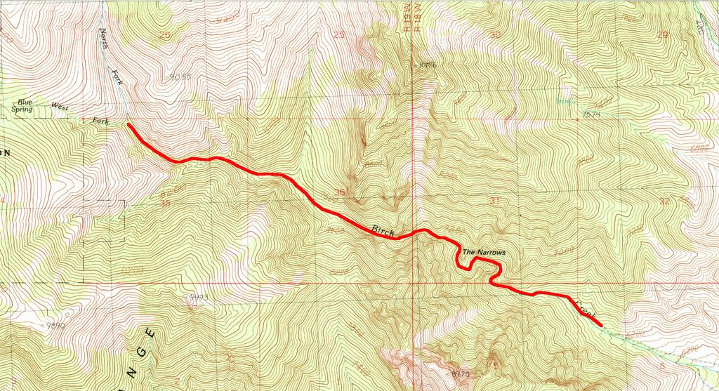
Here is a somewhat misleading map of the route. It's the track you would make if you didn't have to thrash through brush or work around deadfall or repeatedly cross the creek.