Haystack Peak
![/galleries/deep_creeks_haystack_peak_1988/004_Haystack_from_Peak_11598_[Sat_Sep_03_1988].thumbnail.jpg](../galleries/deep_creeks_haystack_peak_1988/004_Haystack_from_Peak_11598_[Sat_Sep_03_1988].thumbnail.jpg)
Getting There
Haystack Peak is the companion to Ibapah Peak — it's the other 12,000-footer in the Deep Creeks. Like Ibapah, it's made of very pale granite, and it has a lovely, deep cirque.
The bad news is that you get to the trailhead via the terrible Toms Creek road. The last time that I drove the Toms Creek road was over 30 years ago, so the road quality has probably changed — it's probably gotten worse! I have driven the road at least twice, and my recollection is that there are a couple of sections that will very likely defeat (or badly damage) Subarus. You have been warned.
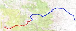
Toms Creek actually runs through the CCC campground, but getting into the upper basin of Toms Creek requires an elaborate detour. Go north from the campground on the main road and immediately bear slightly west (left) after crossing the creek. At 0.8 mi, keep going northwest (right) at the Dell Creek road. At 0.9 mi, stay northwest (left) at the Big Creek road. At 2.8 mi, start heading up the hill. There are a couple of rough switchbacks at the bottom, but eventually the road goes straight up a ridge. I remember one big step on the ridge that required extra care in a short-bed Toyota Land Cruiser. Eventually the road crests a hill and contours into Toms Creek. The road continues west and gradually gets closer to the creek, staying on the north side. At about 5.6 mi, look for a track that crosses the creek to the south (left) side and climbs a hill through sagey meadows. This road goes to a crude old cabin in Indian Farm Creek, located on a private inholding. I don't know if the road is still open past the boundary of the inholding; if not, you may have to park at the boundary.
Although there is plenty of water lower down in Indian Farm Creek, don't count on finding any on this hike.
The Route
If you can't drive to the end of the road, then walk the road to the cabin. It's a pretty area with scattered trees and outcrops, with sagebrush and aspen. Thirty years ago, you could camp near the cabin; I don't know whether the cabin is still there. (You can see the cabin in the photo, behind the gray pick-up truck.) There is a flat area with aspens and granite boulders around the cabin, littered with cow pies. The cabin area is about 2/3 of a mile from the private inholding boundary.
From here, head southwest into the aspens. The goal is to pick up a sloping meadow on the other side of the aspens, and avoid the deadfall as long as possible. Stay to the north (right) side of the meadow. On the south (left) side of the meadow, upper Indian Farm Creek forks; stay in the west (right) fork, which goes to the Haystack Peak cirque.
My recollection of the hike is that it's pleasant and wooded, but there's a fair amount of deadfall. The satellite view shows an oval clearing about 1.5 mi up the route, which should make for a nice break. As you get higher, the trees get sparser and bushwhacking gets less difficult.
The slope to the south leads up to Peak 11598. Pick a good spot to start contouring up to the ridge. It's all pretty straightforward, with alpine grasses and blocks of granite. Once on the ridge, it's just a walk up to the summit (see the opening photo).
The view south into the cirque of Red Cedar Creek is very impressive. Lots of bare rock, many cliffs and towers, with Ibapah Peak looming over everything.
![/galleries/deep_creeks_haystack_peak_1988/008_camping_at_the_Indian_Farm_cabin_[Sat_Sep_03_1988].thumbnail.jpg](../galleries/deep_creeks_haystack_peak_1988/008_camping_at_the_Indian_Farm_cabin_[Sat_Sep_03_1988].thumbnail.jpg)
![/galleries/deep_creeks_haystack_peak_1988/002_headed_toward_the_saddle_[Sat_Sep_03_1988].thumbnail.jpg](../galleries/deep_creeks_haystack_peak_1988/002_headed_toward_the_saddle_[Sat_Sep_03_1988].thumbnail.jpg)
![/galleries/deep_creeks_haystack_peak_1988/003_Ibapah_Peak_seen_through_smoke_[Sat_Sep_03_1988].thumbnail.jpg](../galleries/deep_creeks_haystack_peak_1988/003_Ibapah_Peak_seen_through_smoke_[Sat_Sep_03_1988].thumbnail.jpg)
