Ibapah Azimuth
![/galleries/deep_creeks_ibapah_azimuth_1987/001_Ibapah_Azimuth_[Sat_Sep_19_1987].thumbnail.jpg](../galleries/deep_creeks_ibapah_azimuth_1987/001_Ibapah_Azimuth_[Sat_Sep_19_1987].jpg)
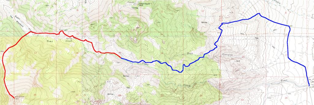
Getting There
Ibapah Azimuth is the high point on the upper rim of Toms Creek. It's just north of Haystack Peak and almost as tall. In the fall, the aspens on the north facing slopes are glorious. Although there is a decent amount of elevation gain, a lot of the climb is on an old dirt track. You can shorten the hike by leaving the track a bit earlier, at the cost of struggling through a bit more deadfall.
Now for the warning: the last time that I drove the Toms Creek road was over 30 years ago, so the road quality has probably changed — it's probably gotten worse! I have driven the road at least twice, and my recollection is that there are a couple of sections that will very likely defeat (or badly damage) Subarus. You have been warned.
Toms Creek actually runs through the CCC campground, but getting into the upper basin of Toms Creek requires an elaborate detour. Go north from the campground on the main road and immediately bear slightly west (left) after crossing the creek. At 0.8 mi, keep going northwest (right) at the Dell Creek road. At 0.9 mi, stay northwest (left) at the Big Creek road. At 2.8 mi, start heading up the hill. There are a couple of rough switchbacks at the bottom, but eventually the road goes straight up a ridge. I remember one big step on the ridge that required extra care in a short-bed Toyota Land Cruiser. Eventually the road crests a hill and contours into Toms Creek. The road continues west and gradually gets closer to the creek, staying on the north side.
At 5.8 mi, there is a gate where the road is closed from 12/1 to 5/31. Above this point, the road climbs steeply to a low point on the northern ridgeline. The road is closed here; in 1987, we found that the road above the saddle became too soft and sandy even for our 4WD.
The Route
![/galleries/deep_creeks_ibapah_azimuth_1987/002_looking_down_Indian_Farm_Creek_[Sat_Sep_19_1987].thumbnail.jpg](../galleries/deep_creeks_ibapah_azimuth_1987/002_looking_down_Indian_Farm_Creek_[Sat_Sep_19_1987].jpg)
The track continues west up the valley, staying on the north (right) side. It reaches a little saddle on the north ridgeline, with a fine view of upper Basin Creek and the bizarre, gigantic quartzite blocks that flank its entrance. The track continues to traverse the slope on the north side of Toms Creek, eventually reaching a pretty meadow littered with pale granite boulders. It's obvious at this point that this bowl is the top of the Toms Creek drainage.
Pick a place to cross the meadow to the south side and start climbing toward the summit. If you go further up the canyon, as shown on the map below, you'll avoid more of the deadfall. We went up the slope through the denser forest and came down on the route shown on the map through sparser forest. I don't remember the deadfall being too awful; the slope is steep but it doesn't have cliff bands or other obstacles.
On the south (far) side of the peak, the big gray cirque of Indian Farm Creek opens up. Haystack Peak looms across the way. You can see the rocky mouth of Indian Farm Creek far below to the east (left).
![/galleries/deep_creeks_ibapah_azimuth_1987/003_the_knife-edge_[Sat_Sep_19_1987].thumbnail.jpg](../galleries/deep_creeks_ibapah_azimuth_1987/003_the_knife-edge_[Sat_Sep_19_1987].jpg)
The route over to Haystack looks reasonable except for the section right next to Ibapah Azimuth, which is a knife-edge with a notch in it. At the time, it looked hairier to me than it probably was, because there was a 40 mph wind blasting at us, forcing us to keep close to the ground. While we were sitting on the peak, a young man came across the knife edge with a bicycle on his shoulder. He said that he was a BYU student who had relatives in Ibapah, and that he was doing a route that he had pioneered in a previous season. He rode the bike from Ibapah up to the Queen of Sheba mine on the west side of Red Mountain, then went cross-country northward over Ibapah Peak, Haystack Peak and Ibapah Azimuth to the saddle south of Rocky Peak, before biking west down The Delle back to the Deep Creek Valley.
I think I would have been less astonished if I'd seen a UFO.
Because the driving route is so complicated, I've marked it in blue. The hiking part is in red.