Peak 10661
![/galleries/deep_creeks_2009/004_aspens_in_the_upper_valley_of_Goshute_Creek_[Sat_May_23_12:45:17_MDT_2009].thumbnail.jpg](../galleries/deep_creeks_2009/004_aspens_in_the_upper_valley_of_Goshute_Creek_[Sat_May_23_12:45:17_MDT_2009].jpg)
Getting There
Peak 10,661 is the high point at the top of Goshute Creek. An old road in Goshute Creek makes this peak a relatively straightforward destination for a Deep Creeks hike.
Having said that, the access road that I used to reach the trailhead is not in great shape. My recollection is that it is not maintained, and it has rocks, washouts and humps in it. The turn-off for this road is about 0.4 mi north of the main road junction just west of Callao.
Go west on this road toward the mountains. At about 3.3 mi out, the road bends north (right); ignore the fainter road coming in on the left. At about 3.4 mi out, bear west again (left) at a fork. The road quality gets quite bad as you approach the mouth of the canyon. At about 5.2 mi, there is a junction with another road coming in from the south; there are some decaying mine buildings here. Park here (if you can make it this far).
The Route
![/galleries/deep_creeks_2009/001_heading_into_the_gorge_of_Goshute_Creek_[Sat_May_23_11:38:02_MDT_2009].thumbnail.jpg](../galleries/deep_creeks_2009/001_heading_into_the_gorge_of_Goshute_Creek_[Sat_May_23_11:38:02_MDT_2009].jpg)
Head west up the rocky old road into the gorge. Don't even think about trying to drive this section — it's in terrible shape, with big boulders and ruts. In the spring, the stream sometimes runs right down the road, and you have to work your way through it and over it. There are a few private cabins along the road; leave them alone.
The gorge is scenic and pretty, with great views back down to the flats. The forest starts out as pinyon-juniper, but soon you begin to see higher elevation trees like white firs and aspens.
![/galleries/deep_creeks_2009/002_the_cabins_at_the_road_junction_[Sat_May_23_12:03:22_MDT_2009].thumbnail.jpg](../galleries/deep_creeks_2009/002_the_cabins_at_the_road_junction_[Sat_May_23_12:03:22_MDT_2009].jpg)
Eventually you emerge from the gorge and the road gets less rocky. There are a couple of old cabins that are worth checking out. A spring is located nearby, but don't count on any water. We saw rhubarb growing in a patch next to the cabins.
Just above the cabins, the road splits. One fork climbs north (right) up the hillside in switchbacks; the other fork, the one that you want, continues up the drainage through shady forest.
![/galleries/deep_creeks_2009/003_just_above_the_gate_[Sat_May_23_12:40:46_MDT_2009].thumbnail.jpg](../galleries/deep_creeks_2009/003_just_above_the_gate_[Sat_May_23_12:40:46_MDT_2009].jpg)
There is a gate on this road fork, but I'm afraid that my memory is vague about the location.
Keep following the main drainage generally westward. There are plenty of aspens on the north-facing slopes, sometimes coming all the way down to the road. There is a fair amount of deadfall to work through.
![/galleries/deep_creeks_2009/005_the_ravine_near_the_top_[Sat_May_23_13:18:11_MDT_2009].thumbnail.jpg](../galleries/deep_creeks_2009/005_the_ravine_near_the_top_[Sat_May_23_13:18:11_MDT_2009].jpg)
Eventually the road peters out in a shallow ravine. We were able to follow a faint foot track here that kept us out of the deadfall at the very bottom. You start seeing tall and vigorous limber pines (and some gorgeous, sculpted dead snags). Keep going up in the main drainage.
Eventually the forest fades away in a bowl. The high point is off to the south (left); angle up the slope to the summit.
![/galleries/deep_creeks_2009/006_looking_north_toward_Haystack_Peak_[Sat_May_23_14:42:44_MDT_2009].thumbnail.jpg](../galleries/deep_creeks_2009/006_looking_north_toward_Haystack_Peak_[Sat_May_23_14:42:44_MDT_2009].jpg)
There are awesome views in every direction. Just to the south is Rocky Peak, only 135 feet higher. Across the Basin rises the huge bulk of Haystack Peak and its northern buttress, marked as Ibapah Azimuth on the map. The salt flats stretch away to the east. To the west, the land drops away steeply to the Deep Creek Valley.
![/galleries/deep_creeks_oro_del_rey_mine_1995/001_edge_of_the_cliff_[Sun_May_28_1995].thumbnail.jpg](../galleries/deep_creeks_oro_del_rey_mine_1995/001_edge_of_the_cliff_[Sun_May_28_1995].jpg)
Back at the cabins, if you choose to go up the switchbacks on the north side of the canyon, you eventually come out at the Oro del Rey Mine. I'm not sure how many of the mine structures will be left now, 25 years after this photo, but the view from the top of the cliff was very nice.
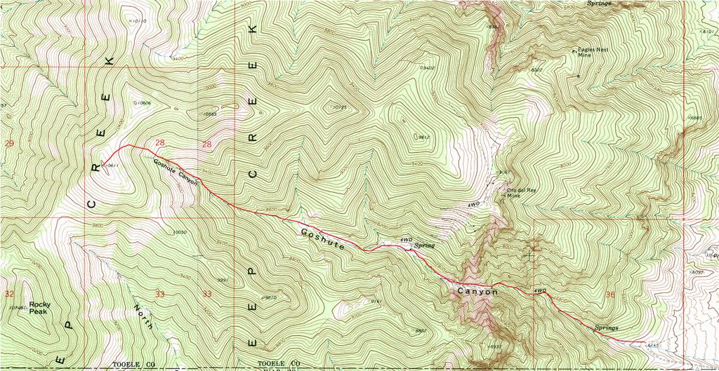
Here is a map of the route.