Red Mountain
![/galleries/deep_creeks_red_mtn_1989/017_Kira_on_the_route_down_[Sun_May_28_1989].thumbnail.jpg](../galleries/deep_creeks_red_mtn_1989/017_Kira_on_the_route_down_[Sun_May_28_1989].jpg)
Getting There
Red Mountain is the peak just to the south of saddle at the top of the Granite Creek trail. I think most people approach it from that saddle, where it's a slog (0.6 mi, 1,500 ft elevation gain) up a loose, rubble-filled avalanche chute.
That sounds pretty bad, but I found a way to make it worse, by starting from the foothills and attacking the peak head-on. No one wanted to return the same way, so we came down Trout Creek, which was longer but much more pleasant. We had already reconnoitered Trout Creek on the previous day, so we knew where to find the faint track through the streamside forest, back to the end of the road, then down the road to the bottom. The loop took Gayle and Bob 12 hours, and John, Kira and I did it in 13 hours.
I'm going to describe the route as though we'd gone up the way that we came down. If you're a glutton for punishment, I'll describe the full frontal route at the end. Trout Creek has a very pretty canyon with a year-round stream, one of the few remaining refuges of the Bonneville cutthroat trout. A massive, spike-like crag, Peak 10,621, hovers over the canyon to the south. The lower part of the canyon has a decrepit dirt road that leads to some old mine diggings, but after that, you have to thread your way through deadfall on a very lightly used track to the upper basin. The upper canyon is shady and pleasant, and there are some very pretty lunch spots among the aspens.
I've been up Trout Creek Canyon three times, but the most recent time was 1995, and most of the details below are from 1989. Since my information is so dated, you should take it with a (huge) grain of salt.
Here are some driving directions, courtesy of Google Maps. To get to Trout Creek from the CCC campground, head south 8.1 mi on the Snake Valley Road to the Trout Creek road. Turn west (right) and head up the hill. At 2.8 mi on this road, ignore two lesser roads on the right and curve south and west into the mouth of the canyon. There used to be some nice camping spots just before the first ford of the creek, and I recommend that you park there, about 4.7 mi up the road. There are some handsome red cliffs to the south across the stream, and flat spots for tents. Above the first ford, the road is seasonally closed, and it's probably still in terrible shape, so I'm going to assume that you will walk it.
The Route
![/galleries/deep_creeks_trout_creek_1989/008_sunset_in_camp_[Sat_May_27_1989].thumbnail.jpg](../galleries/deep_creeks_trout_creek_1989/008_sunset_in_camp_[Sat_May_27_1989].jpg)
Starting from the camp site, follow the jeep track up the hill about 350 yards to the first ford, and cross to the south side of the creek. At about 1.2 mi you'll reach the second ford, which can be awkward to cross when the creek is high.
![/galleries/deep_creeks_trout_creek_1989/001_on_the_faint_track_[Sat_May_27_1989].thumbnail.jpg](../galleries/deep_creeks_trout_creek_1989/001_on_the_faint_track_[Sat_May_27_1989].jpg)
The road stays on the north side of the creek until it peters out at a small old mine site at roughly 2 mi. This is where the real routefinding starts. There used to be (and hopefully still is) a very faint track that leaves the end of the road and crosses the creek to the south side. Look for the old tread as it sneaks under deadfall and through shrubbery. My recollection is that the trail stays on the south bank through this section.
![/galleries/deep_creeks_trout_creek_1995/004_the_wall_of_Peak_10,621_[Sat_May_27_1995].thumbnail.jpg](../galleries/deep_creeks_trout_creek_1995/004_the_wall_of_Peak_10,621_[Sat_May_27_1995].jpg)
It's very slow going in the streamside thicket. Resist the temptation to cross to the north side, where there are big tangles of wild rose. At about 2.6 mi, you come out of the forest onto the toe of a large rock glacier. There is a great view south up toward the spiky top of Peak 10,621. You can pick out a track across the quartzite boulders in places.
![/galleries/deep_creeks_trout_creek_1989/007_a_rock_glacier_[Sat_May_27_1989].thumbnail.jpg](../galleries/deep_creeks_trout_creek_1989/007_a_rock_glacier_[Sat_May_27_1989].jpg)
The track ducks back into the forest, then emerges onto another big rock glacier. The track follows the base of the boulder pile, then cuts diagonally up it — look for it among the boulders.
![/galleries/deep_creeks_trout_creek_1989/004_the_upper_basin_[Sat_May_27_1989].thumbnail.jpg](../galleries/deep_creeks_trout_creek_1989/004_the_upper_basin_[Sat_May_27_1989].jpg)
The track fades out as it reaches the upper glacial section of the canyon. The cross-country travel here is much easier than it is below. The going is slightly better on the north side of the creek, in my recollection. There is thick conifer forest on the north facing slopes, along with patches of aspen that are gorgeous in spring, and surely in fall as well. At about 3.7 mi, you reach the fork that comes down from Trout Peak to the west. Keep going north in the main fork.
At 4 mi, there is another substantial fork coming in from the northwest; stay in the eastern (right) fork as it climbs more steeply toward the summit ridge. There are some cliff bands on the slope to the west (left) that you want to avoid at 5 mi. Once above the cliff bands, pick a route up the rubbly slope to the ridge at 5.7 mi. Our group thought that the going was a little easier on the west (left) side of the bowl, but I'm not sure that it makes a big difference. The high point is a little bit east (right) of the head of the bowl. It's one of several humps, and it doesn't really stand out, so you may need your GPS to decide which hump is really the summit.
![/galleries/deep_creeks_red_mtn_1989/015_John_on_top_[Sun_May_28_1989].thumbnail.jpg](../galleries/deep_creeks_red_mtn_1989/015_John_on_top_[Sun_May_28_1989].jpg)
The top is just a pile of rocks, but as you might expect, it has a fantastic view. The summit is about 6.4 mi out from the camping area, following the route that we took.

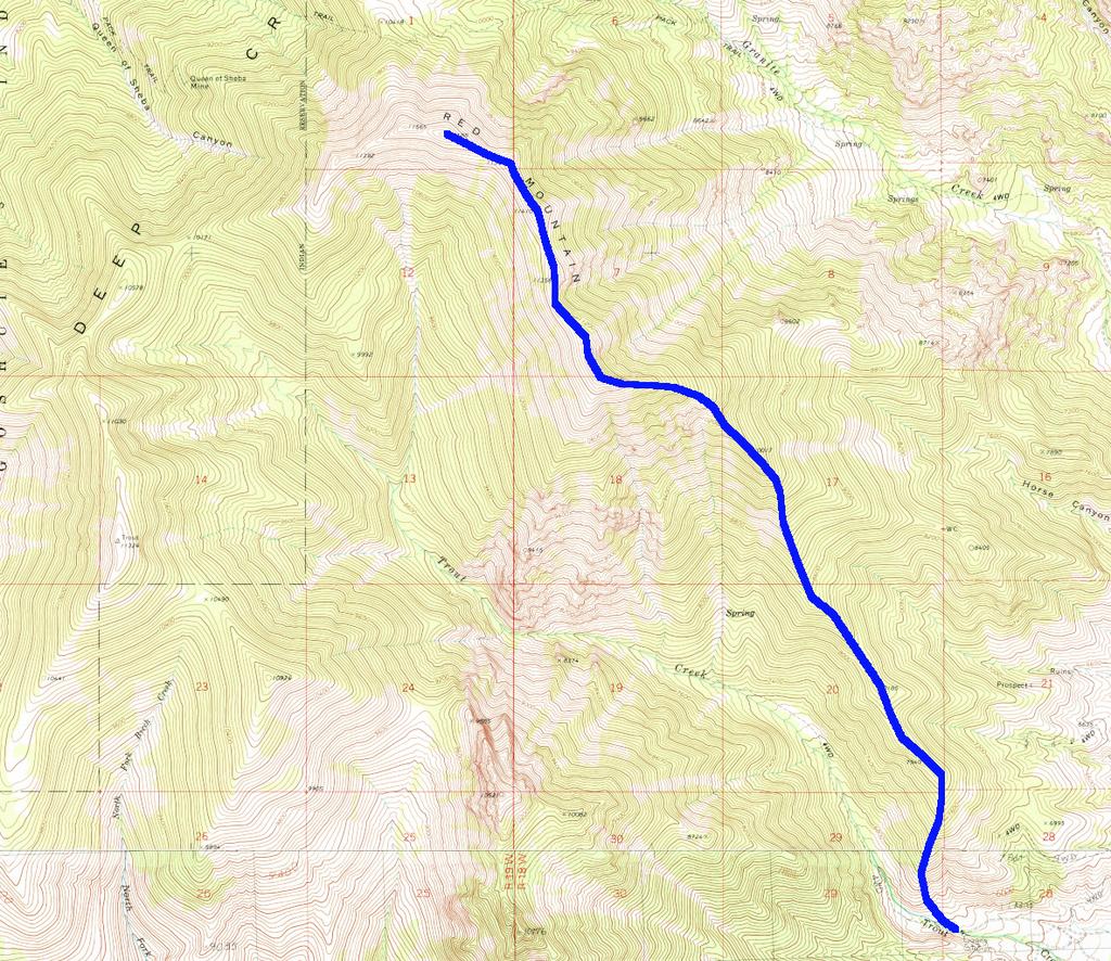
Here is an approximate map of the route. Not only has it been a long time since I did this hike, I never took exactly the same route twice going up and down Trout Creek.
![/galleries/deep_creeks_red_mtn_1989/002_bristly_[Sun_May_28_1989].thumbnail.jpg](../galleries/deep_creeks_red_mtn_1989/002_bristly_[Sun_May_28_1989].jpg)
You can cut a bit more than a mile of the (one-way) distance off of this hike by going straight up the ridge, instead of heading up the valley. It's a brutally steep bushwhack through mountain mahogany on crappy footing; I figure that the worst part climbs 3000 ft in 1.5 mi. At least there are some nice bristlecones to greet you up near treeline. It's about 3.6 mi to the summit ridge.
![/galleries/deep_creeks_red_mtn_1989/005_headed_west_[Sun_May_28_1989].thumbnail.jpg](../galleries/deep_creeks_red_mtn_1989/005_headed_west_[Sun_May_28_1989].jpg)
And then it's another 1.6 mi of tiring up and down over rubble piles to the actual summit. It can be tough to figure out which pile is the tallest; as mentioned above, a GPS will help.
Here is a map of the direct route. Enjoy!