Sheep Creek
![/galleries/deep_creeks_north_1995/004_cliffy_[Thu_Apr_23_1995].thumbnail.jpg](../galleries/deep_creeks_north_1995/004_cliffy_[Thu_Apr_23_1995].thumbnail.jpg)
Getting There
The east side of the Deep Creeks has a quartzite cliff band that crosses every drainage from Basin Creek north. Sheep Canyon is one of the northernmost east-side canyons and it provides a fun scramble up through the cliffs.
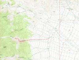
The road to Sheep Canyon is pretty marginal. It starts at the Canyon Station Pony Express site in Overland Canyon. After visiting the site, go back to the entrance and make a hard southwest (right) turn on a rough dirt track. Follow this track along the bench, going down and up at several washes, until at 2.4 mi out, just after a wash crossing, you reach an even more marginal track that takes off south and then immediately west (right) toward the mountains. About halfway to the mountain front, you'll encounter the WSA boundary. I don't know whether it's marked; use your best judgment about where to park.
The Route
Walk up the road until you can find a reasonable spot to drop south (left) into the draw. The draw soon starts to get bumpy, with boulders and ledges of buff-to-red quartzite. The canyon bottom is grassy and has pleasant walking.
Soon the walls close in and you're in a lovely garden of rocks. In the spring the stream will flow with snowmelt. You're now walking mostly on bare rock, with occasional patches of soil that have filled in below ledges. There are some brushy sections, but it's not too bad.
The streambed has some water pockets. They're pretty, but they can be a little awkward to skirt. The incline gets steeper and steeper.
At one point we found our way forward blocked by a pool. We found a steep ramp off to the side and scrambled up it to see if there was a way to bypass the obstacle. The detour actually worked well.
But of course there was another pool after the first one. We tried some more detours, but eventually we turned around so that we could have enough time to try another canyon before we had to head back to SLC. We didn't make it all the way to the top of the cliff band, but maybe we'll get there on another trip.
![/galleries/deep_creeks_north_1995/001_bottom_of_the_narrows_[Thu_Apr_23_1995].thumbnail.jpg](../galleries/deep_creeks_north_1995/001_bottom_of_the_narrows_[Thu_Apr_23_1995].thumbnail.jpg)
![/galleries/deep_creeks_north_1995/002_rock_garden_[Thu_Apr_23_1995].thumbnail.jpg](../galleries/deep_creeks_north_1995/002_rock_garden_[Thu_Apr_23_1995].thumbnail.jpg)
![/galleries/deep_creeks_north_1995/003_waterpocket_[Thu_Apr_23_1995].thumbnail.jpg](../galleries/deep_creeks_north_1995/003_waterpocket_[Thu_Apr_23_1995].thumbnail.jpg)
![/galleries/deep_creeks_north_1995/005_ramp_[Thu_Apr_23_1995].thumbnail.jpg](../galleries/deep_creeks_north_1995/005_ramp_[Thu_Apr_23_1995].thumbnail.jpg)
![/galleries/deep_creeks_north_1995/006_on_a_detour_[Thu_Apr_23_1995].thumbnail.jpg](../galleries/deep_creeks_north_1995/006_on_a_detour_[Thu_Apr_23_1995].thumbnail.jpg)
