Trout Creek
![/galleries/deep_creeks_trout_creek_1995/005_stacked_slabs_[Sat_May_27_1995].thumbnail.jpg](../galleries/deep_creeks_trout_creek_1995/005_stacked_slabs_[Sat_May_27_1995].jpg)
Getting There
This is the first part of the hikes to Red Mountain and Trout Peak, but it's a fine day hike just to go up to the narrows and back. The quartzite crags are fantastic, and the perennial stream is lovely. It's both a positive and a negative that this canyon is so wild: it has amazing wilderness values, but it doesn't have a real trail. Instead, you'll have to work to find a faint use trail that weaves through the forest and brush and rockpiles along the stream.
I've been up Trout Creek Canyon three times, but the most recent time was 1995. Since my information is so dated, you should take it with a (huge) grain of salt.
Here are some driving directions, courtesy of Google Maps. To get to Trout Creek from the CCC campground, head south 8.1 mi on the Snake Valley Road to the Trout Creek road. Turn west (right) and head up the hill. At 2.8 mi on this road, ignore two lesser roads on the right and curve south and west into the mouth of the canyon. There used to be some nice camping spots just before the first ford of the creek, and I recommend that you park there, about 4.7 mi up the road. There are some handsome red cliffs to the south across the stream, and flat spots for tents. Above the first ford, the road is seasonally closed, and it's probably still in terrible shape, so I'm going to assume that you will walk it.
The Route
![/galleries/deep_creeks_trout_creek_1995/003_creek_and_meadow_[Sat_May_27_1995].thumbnail.jpg](../galleries/deep_creeks_trout_creek_1995/003_creek_and_meadow_[Sat_May_27_1995].jpg)
Starting from the camp site, follow the jeep track up the hill about 350 yards to the first ford, and cross to the south side of the creek. At about 1.2 mi you'll reach the second ford, which can be awkward to cross when the creek is high.
![/galleries/deep_creeks_trout_creek_1989/003_the_north_side_[Sat_May_27_1989].thumbnail.jpg](../galleries/deep_creeks_trout_creek_1989/003_the_north_side_[Sat_May_27_1989].jpg)
The road stays on the north side of the creek until it peters out at a small old mine site at roughly 2 mi. This is where the real routefinding starts. There used to be (and hopefully still is) a very faint track that leaves the end of the road and crosses the creek to the south side. Look for the old tread as it sneaks under deadfall and through shrubbery. My recollection is that the trail stays on the south bank through this section.
![/galleries/deep_creeks_trout_creek_1989/002_crags_[Sat_May_27_1989].thumbnail.jpg](../galleries/deep_creeks_trout_creek_1989/002_crags_[Sat_May_27_1989].jpg)
It's very slow going in the streamside thicket. Resist the temptation to cross to the north side, where there are big tangles of wild rose. At about 2.6 mi, you come out of the forest onto the toe of a large rock glacier. There is a great view south up toward the spiky top of Peak 10,621. You can pick out a track across the quartzite boulders in places.
![/galleries/deep_creeks_trout_creek_1995/006_lunch_[Sat_May_27_1995].thumbnail.jpg](../galleries/deep_creeks_trout_creek_1995/006_lunch_[Sat_May_27_1995].jpg)
The track ducks back into the forest, then emerges onto another big rock glacier. The track follows the base of the boulder pile, then cuts diagonally up it — look for it among the boulders. Choose a spot for lunch on the rocks and enjoy the view.
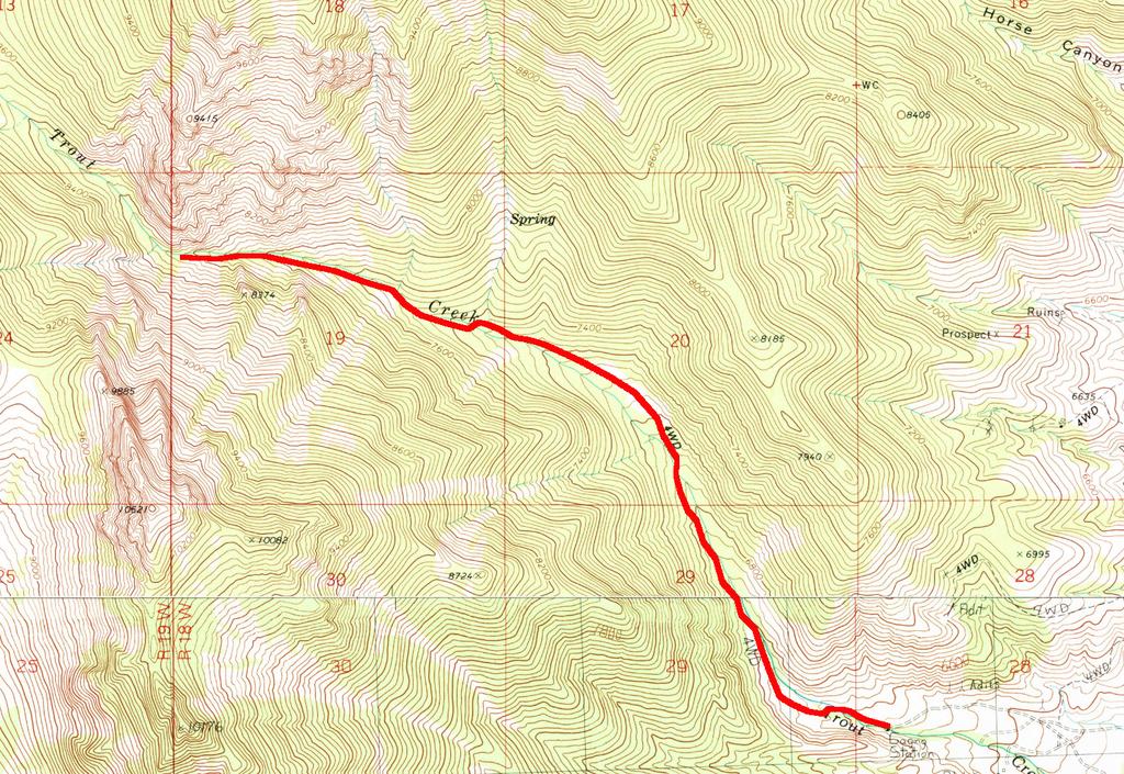
Here is a map of the route. Enjoy!