Trout Peak
![/galleries/deep_creeks_trout_peak_1992/006_looking_south_[Sun_May_24_1992].thumbnail.jpg](../galleries/deep_creeks_trout_peak_1992/006_looking_south_[Sun_May_24_1992].thumbnail.jpg)
Getting There
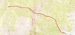
Peak 11,324 is the high point on the west rim of the Trout Creek Basin; it's marked “Trout” on the USGS map, so I call it Trout Peak. It's the southernmost 11,000-ft peak in the Deep Creeks. The hike is a fairly straightforward cross-country ascent going west in a fork just past the narrows of Trout Creek. The canyon gets lots of avalanches and my recollection is that there is a fair amount of debris in it, which you can avoid by staying on the north side.
While preparing this write-up, it finally clicked on me that the last mile or so of the hike is inside the Goshute Reservation. I don't know what their policy is about public access to this peak; you probably want to ask before heading up there.
I've been up Trout Creek Canyon three times, but the most recent time was 1995. Since my information is so dated, you should take it with a (huge) grain of salt.
Here are some driving directions, courtesy of Google Maps. To get to Trout Creek from the CCC campground, head south 8.1 mi on the Snake Valley Road to the Trout Creek road. Turn west (right) and head up the hill. At 2.8 mi on this road, ignore two lesser roads on the right and curve south and west into the mouth of the canyon. There used to be some nice camping spots just before the first ford of the creek, and I recommend that you park there, about 4.7 mi up the road. There are some handsome red cliffs to the south across the stream, and flat spots for tents. Above the first ford, the road is seasonally closed, and it's probably still in terrible shape, so I'm going to assume that you will walk it.
The Route
Follow the dirt track from the parking area to its end at an old mine, about 2 mi. The track fords the creek twice, ending up on the north side. Look for a faint trail that crosses the creek to the south side and winds through deadfall in the forest along the bank. At 2.6 mi, the trail starts crossing rock glaciers as it gets close to the narrows.
Push on past the narrows, following the path of least resistance. At about 3.7 mi, a substantial side canyon comes down from the west (left). It's the first major side canyon after the narrows, and it is wide and green. Cross to the north bank of the stream in this canyon and turn west (left) to go up it.
This last section is fairly steep — it's almost 3,000 ft of elevation gain in a little over a mile and a half. Keep working west, and stay on the north (right) side of the stream to avoid the avalanche chutes that come down the slopes on the other side. Eventually you end up in avalanche terrain anyway, as you get toward the top of the drainage. My recollection is that the talus isn't that bad, but early in the season you have to cross a cornice just below the summit. The top should be about 5.3 mi from the trailhead.
The summit isn't very dramatic on its own, but the views are very nice. The foreground has Trout Creek to the east, Birch Creek to the south, Johnson Canyon to the west. In the distance to the north you can see Ibapah Peak, and further to the south you can make out Mt Moriah. Early in the season the slopes have brilliant green splotches of aspen, which are surely brilliant yellow in the fall.
![/galleries/deep_creeks_trout_peak_1992/002_steep_[Sun_May_24_1992].thumbnail.jpg](../galleries/deep_creeks_trout_peak_1992/002_steep_[Sun_May_24_1992].thumbnail.jpg)
![/galleries/deep_creeks_trout_peak_1992/003_the_Trout_Peak_fork_[Sun_May_24_1992].thumbnail.jpg](../galleries/deep_creeks_trout_peak_1992/003_the_Trout_Peak_fork_[Sun_May_24_1992].thumbnail.jpg)
![/galleries/deep_creeks_trout_peak_1992/008_Peak_10,621_with_aspens_[Sun_May_24_1992].thumbnail.jpg](../galleries/deep_creeks_trout_peak_1992/008_Peak_10,621_with_aspens_[Sun_May_24_1992].thumbnail.jpg)
![/galleries/deep_creeks_trout_peak_1992/004_Ibapah_Peak_and_Red_Mountain_from_Trout_Peak_[Sun_May_24_1992].thumbnail.jpg](../galleries/deep_creeks_trout_peak_1992/004_Ibapah_Peak_and_Red_Mountain_from_Trout_Peak_[Sun_May_24_1992].thumbnail.jpg)
