Ashdown Gorge
![/galleries/cedar_breaks_2014/016_the_walls_are_closing_in_[Fri_Jul_4_14:48:56_MDT_2014].thumbnail.jpg](../galleries/cedar_breaks_2014/016_the_walls_are_closing_in_[Fri_Jul_4_14:48:56_MDT_2014].jpg)
Getting There
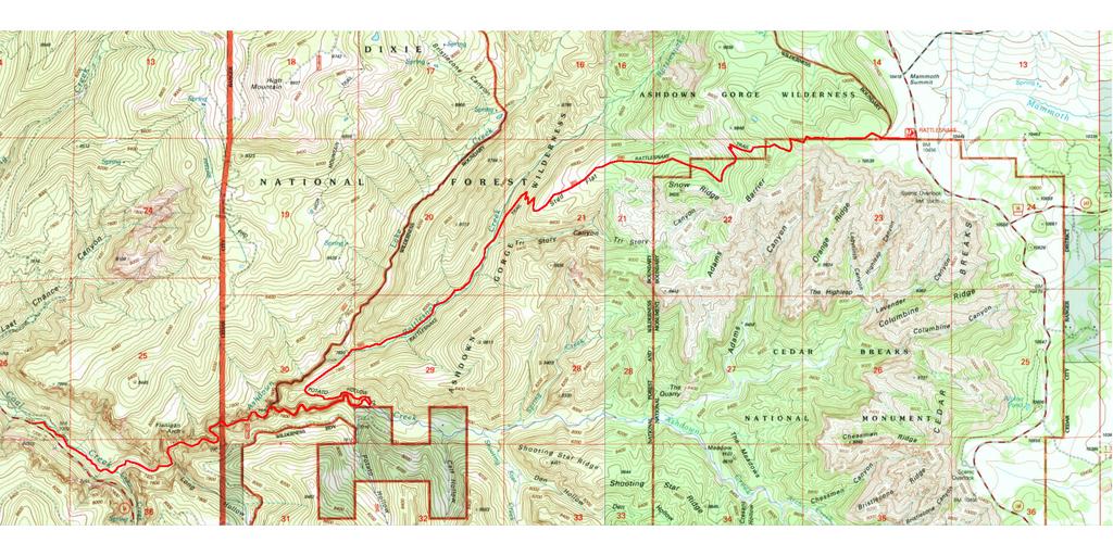
The Ashdown Gorge hike is relatively well known among the hikes in and around Cedar Breaks National Monument, but since Cedar Breaks is relatively unknown, I'm including the hike here. The hike mostly stays out of the national monument, running along its northern boundary and then dropping into the Forest Service's Ashdown Gorge Wilderness. Note that this is a shuttle hike — you will need to leave a vehicle at the bottom of the gorge so that you can drive back to the trailhead.
The easiest way to get to the trailhead from Salt Lake is to take I-15 to Cedar City and head east. Get off the freeway at exit 59, which loops around to the north and tees into 200 North St. There are some gas stations nearby where you can fill up. Go east (right) on 200 North / SR 56 to Main St, about 1.1 mi. Go south (right) on Main St to Center St / SR 14, about 0.2 mi. Turn east (left) and take Center St / SR 14 out of town and up Coal Creek / Cedar Canyon. In about 7.7 mi, you'll reach an area where a landslide covered the road several years ago, and there is now a broad parking area on the north (left), with concrete barriers to keep you from driving off the edge. Park your shuttle vehicle here. My GPS reading here was UTM 0328525 4166840.
The road turns south and climbs. The canyon section above here is really pretty, but keep an eye out for RVs that cut corners. The road switchbacks and then curves through a pink bowl before coming out on the south flank of a mountain, with great views off to Zion National Park. The road climbs over a saddle and comes out on top of the Markagunt Plateau. At a junction, turn north (left) on SR-148 and drive into Cedar Breaks National Monument. If you're going to park inside the monument, you should stop at the visitor center and pay the fee. Note that the visitor center has flush toilets (!).
Keep going north on SR-148. The speed limit is just 35 in the national monument, so watch out. In the fall, the aspens in this area really glow with color. At the junction with SR-143, stay northbound (straight). In a mile or so, you will reach the northern boundary of the national monument; the trailhead is just on the other side, where there is a large sign. My GPS reading here was UTM 0337957 4169780.
You can also reach the area by driving south from Brian Head. Look for the trailhead and the national monument boundary just south of the turn-off for the Brian Head summit road.
Some words about preparation... This is a long downhill hike — it's at least 12 mi, and it will be longer if you check out various diversions. The gorge has a perennial stream, and it's pointless to try to keep your feet dry. The water can be cold; I wore neoprene socks with river shoes, and I was fine. Boots with drains would be even better.
Once you are in the gorge, you are at the mercy of the weather. Afternoon thunderstorms are common in the summer. Don't get caught in a flash flood — start the hike early before the rain comes down, and pay attention to weather reports.
Since the trail starts at 10,000 ft and ends at 7,000 ft, you can realistically only do the hike in the summer. SR-148 is normally closed October through May due to snow in any event.
The Route
![/galleries/cedar_breaks_2014/017_in_the_forest_[Fri_Jul_4_09:58:22_MDT_2014].thumbnail.jpg](../galleries/cedar_breaks_2014/017_in_the_forest_[Fri_Jul_4_09:58:22_MDT_2014].jpg)
Walt Haas and Gretchen Siegler
The trail starts west across a meadow, parallel to the fenceline that marks the boundary with the national monument. It enters an open high-elevation (10,000+ ft) forest. Look for white Utah columbines and other flowers.
![/galleries/cedar_breaks_2014/018_the_amphitheater_[Fri_Jul_4_10:04:46_MDT_2014].thumbnail.jpg](../galleries/cedar_breaks_2014/018_the_amphitheater_[Fri_Jul_4_10:04:46_MDT_2014].jpg)
There are a couple of somewhat confusing junctions where trails take off to the south (left) to go to overlooks into Cedar Breaks. By all means check out the overlooks — this photo shows some of what you'll see. The main trail bears to the right, however.
![/galleries/cedar_breaks_2014/019_Snow_Ridge_[Fri_Jul_4_10:32:51_MDT_2014].thumbnail.jpg](../galleries/cedar_breaks_2014/019_Snow_Ridge_[Fri_Jul_4_10:32:51_MDT_2014].jpg)
The trail drops down through mixed aspen and conifer forest. It comes out onto a meadowy slope with a nice view, and cuts a few switchbacks before heading back into the forest.
The pale ridgeline in the near distance in the photo is Snow Ridge. The trail runs below it in fairly thick forest with lots of deadfall on the trail (when we did it). It looks like you might get a fine view into Cedar Breaks if you bushwhack up the slope to the top of the ridge, but I haven't done it.
![/galleries/cedar_breaks_2014/020_Stud_Flat_[Fri_Jul_4_11:19:24_MDT_2014].thumbnail.jpg](../galleries/cedar_breaks_2014/020_Stud_Flat_[Fri_Jul_4_11:19:24_MDT_2014].jpg)
The trail picks up a west-trending ridge and eventually emerges from the forest into a wide meadow named Stud Flat. The views are impressive in this stretch. Look for sego lilies (in season).
At the bottom of Stud Flat, the trail switchbacks down a fairly steep slope through heavy forest into Rattlesnake Creek. When we did this section (2014), there was a fair amount of obnoxious deadfall on the trail, and there were soggy spots near springs.
The trail eventually runs above and parallel to the creek. It takes its time descending to the creek, and eventually crosses it. There are some very pretty agates in the streambed.
![/galleries/cedar_breaks_2014/021_Rattlesnake_Creek_[Fri_Jul_4_13:18:41_MDT_2014].thumbnail.jpg](../galleries/cedar_breaks_2014/021_Rattlesnake_Creek_[Fri_Jul_4_13:18:41_MDT_2014].jpg)
The trail stays on the north bank of the stream for the next mile and a half or so. It's pleasant going in a ponderosa / pinyon forest. Eventually the trail crosses the stream at a small waterfall and heads diagonally southwest up a slope to a low saddle.
![/galleries/cedar_breaks_2014/022_the_gorge_from_above_[Fri_Jul_4_13:40:43_MDT_2014].thumbnail.jpg](../galleries/cedar_breaks_2014/022_the_gorge_from_above_[Fri_Jul_4_13:40:43_MDT_2014].jpg)
At this point, the trail cuts back to the east. Grand views open up into the Cedar Breaks amphitheater. The trail descends toward Ashdown Creek, and it ends up on top of a cliff band above the start of the gorge. The view whets your appetite for more.
When the trail finally reaches the stream, there are some convenient slabs near the water where you can change into your wading gear. If the weather looks really dismal or the water is already high, you should be able to abort the trip here and hike out of the canyon to the south on the Potato Hollow trail. You'll have to hitch back to one of your cars, but that's better than drowning.
![/galleries/cedar_breaks_2014/023_getting_into_the_good_part_[Fri_Jul_4_14:08:07_MDT_2014].thumbnail.jpg](../galleries/cedar_breaks_2014/023_getting_into_the_good_part_[Fri_Jul_4_14:08:07_MDT_2014].jpg)
As you head west (right) down the creek, the walls of the gorge rise fairly quickly. It's a fun change from many other classic southern Utah hikes to see the green forest draped over the cliff bands above you.
![/galleries/cedar_breaks_2014/024_at_the_fork_with_Rattlesnake_Creek_[Fri_Jul_4_14:39:16_MDT_2014].thumbnail.jpg](../galleries/cedar_breaks_2014/024_at_the_fork_with_Rattlesnake_Creek_[Fri_Jul_4_14:39:16_MDT_2014].jpg)
After a mile or so, a substantial tower on the north (right) side of the gorge marks the entrance of Rattlesnake Creek. It looks like it would be fun to hike up the side canyon, but when I hiked the gorge (July 2014), the weather started to get threatening here, so we continued on down. The gorge opens up briefly just below the junction and the walls get significantly taller.
![/galleries/cedar_breaks_2014/025_deeper_and_deeper_[Fri_Jul_4_14:46:54_MDT_2014].thumbnail.jpg](../galleries/cedar_breaks_2014/025_deeper_and_deeper_[Fri_Jul_4_14:46:54_MDT_2014].jpg)
Walt Haas
At this point, you spend a lot of time wading in the stream because the canyon is fairly narrow and because it's just too slow to try to stay dry up on the banks. The canyon makes some big zigs and zags.
![/galleries/cedar_breaks_2014/026_almost_touching_overhead_[Fri_Jul_4_14:58:51_MDT_2014].thumbnail.jpg](../galleries/cedar_breaks_2014/026_almost_touching_overhead_[Fri_Jul_4_14:58:51_MDT_2014].jpg)
In one spot, the walls almost touch far above you. It's a dramatic scene.
![/galleries/cedar_breaks_2014/027_coquina_[Fri_Jul_4_15:16:47_MDT_2014].thumbnail.jpg](../galleries/cedar_breaks_2014/027_coquina_[Fri_Jul_4_15:16:47_MDT_2014].jpg)
There isn't as much agate in the stream bed as there is in Rattlesnake Creek, but there are other interesting rocks. Here is a shot of a slab of limestone that's just packed with shells. This kind of formation is called coquina.
![/galleries/cedar_breaks_2014/028_Flanigan_Arch_[Fri_Jul_4_15:21:37_MDT_2014].thumbnail.jpg](../galleries/cedar_breaks_2014/028_Flanigan_Arch_[Fri_Jul_4_15:21:37_MDT_2014].jpg)
Not far below the coquina slabs, you can see Flanigan Arch up above you on the north side of the stream. If you want to see the arch, you should stay on the south side of the stream as much as possible, because the arch is perched above a 150-ft wall that blocks your view from the very bottom. The arch is quite large, but it's fairly far away from the stream, so it doesn't look quite as big as it really is.
In less than half a mile from the arch, the gorge begins to open up. You have to work your way through debris that has piled up from floods, but it's not very difficult. You can hear traffic on SR-14 well before you reach the junction with Crow Creek, where the stream bends to the northwest.
The last section is somewhat disagreeable. The stream has been altered by the construction of the huge berm that takes SR-14 through the landslide area. The streamside becomes quite brushy, and the stream alternates between wide and muddy, and narrow and eroded. If you want, you can carefully work your way up the very steep and very loose slope of the berm to the highway. The alternative is to bash through the brush downstream until the slope gets a little less obnoxious or until you meet up with a dirt road that comes down to the stream. It's a very slow half mile to the dirt road, and you have to scramble past an old irrigation diversion which the stream now flows over in a waterfall. Pick your poison.
Once you're up on the berm, the area is quite scenic and you can forget about your scratches. Find your shuttle vehicle and head back up SR-14 to Cedar Breaks.
The Ashdown Gorge Wilderness actually doesn't contain much of Ashdown Gorge. A good chunk of the gorge, including Flanigan Arch, is outside of the national forest. On the national forest, there is a cherry-stem up the gorge to a private inholding in upper Ashdown Creek. Only the north side of the gorge is in the wilderness in this section. I didn't wander upstream here, although it was tempting — if you do it, look out for private property signs and avoid getting into trouble.