Crystal Peak
![/galleries/wah_wahs_2011/000_Crystal_Peak_[Sat_May_28_13:19:26_MDT_2011].thumbnail.jpg](../galleries/wah_wahs_2011/000_Crystal_Peak_[Sat_May_28_13:19:26_MDT_2011].jpg)
Getting There
Crystal Peak is a bright white knob at the northern end of the Wah Wah Mountains. You can see it from many miles away, because it stands out so spectacularly from its surroundings, in spite of the fact that it is only 7,106 feet high.
Close-up, the peak looks even stranger. It is covered with tafoni — a type of erosion in which many small holes are produced in soft rock. The mountain looks moth-eaten. I have also described the mountain as a huge pile of melting chocolate-chip ice cream. But none of the metaphors really do it justice.
The rock is total crap. If you take off exploring the area (which I encourage, because there are all kinds of weird formations to check out), be aware that the rock is brittle and loaded with gravel / choss. You really have to watch your footing all of the time. The formation is called the Tunnel Springs Tuff, a moderately welded volcanic deposit that also pops up in a few locations east and west of the peak. The chocolate chips in the rock are bits of neighboring non-volcanic rocks that got shattered and mixed into the concrete-like matrix. The tuff is more fertile than the quartzite and limestone that surrounds it, and it supports a tiny community of ponderosa pines.
I visited Crystal Peak in 2011 with my friend Jerry Hatch. It took us 4 hours to figure out the route to the summit. I came back with my friend Walt Haas in 2014 and we were on top in 45 minutes or so. The route isn't obvious, but it's not hard as long as you know where you are going. There is some class 3 scrambling with loose rock, but it's not very difficult. The views from the top are grand.
From SR 257 between Delta and Milford, turn off at the Black Rock Road (47 mi south of US 6) and head west about 36 mi. In general you just follow the better-quality road at every junction, although there is a somewhat confusing spot south of Sevier Lake where you want to bear southwest (left) rather than bear north to a salt factory on the lake. After you catch sight of the unmistakable peak, the route becomes fairly obvious.
There are a few undeveloped camping areas on either side of the road just before Crystal Peak Pass, where the main road descends sharply to a drainage on the north side of the peak. You start the hike on the south side of the road near the pass; my GPS waypoint shows UTM 0274987 4297212.
The Route
![/galleries/wah_wahs_2011/001_tafoni_[Sat_May_28_13:33:53_MDT_2011].thumbnail.jpg](../galleries/wah_wahs_2011/001_tafoni_[Sat_May_28_13:33:53_MDT_2011].jpg)
Head cross-country south along the east flank of the peak. There are some use trails in the sand, but it's more interesting to get out on the rock right below the walls. Check out the bizarre tafoni.
![/galleries/wah_wahs_2011/002_a_scary_couloir_[Sat_May_28_13:50:06_MDT_2011].thumbnail.jpg](../galleries/wah_wahs_2011/002_a_scary_couloir_[Sat_May_28_13:50:06_MDT_2011].jpg)
Work your way into a draw that climbs to a saddle on the south side of the peak. There are several steep couloirs that come down from the top of the peak that look appealing, but they are really nasty, with crumbly rock and brush. I checked out the couloir in this photo; retreating from the couloir was very slow and slippery.
![/galleries/wah_wahs_2011/003_brach_fossil_[Sat_May_28_15:17:30_MDT_2011].thumbnail.jpg](../galleries/wah_wahs_2011/003_brach_fossil_[Sat_May_28_15:17:30_MDT_2011].jpg)
The bottom of the wash can be rocky and brushy, and in 2014 we found a big, fat and lazy rattlesnake under a pinyon pine. The going is definitely easier (but still steep) if you drift south (left) onto the limestone ridge. However, the scenery is cooler if you persist in the wash.
At the top of the bowl, you can either pick your way through the crumbly ledges or you can cut southwest (left) up a steep, sandy draw. Once on top, you can traverse north (right) toward the south face of the mountain. The top of the ridge has a fun puncture hole that you can (carefully) walk over.
Jerry Hatch and I explored the country beyond the pass, where we found this fantastic brachiopod fossil in a chunk of non-volcanic rock that got caught up in the eruption. The view down the north slope from the west ridge is extremely cool.
![/galleries/wah_wahs_2011/004_the_X_[Sat_May_28_17:01:26_MDT_2011].thumbnail.jpg](../galleries/wah_wahs_2011/004_the_X_[Sat_May_28_17:01:26_MDT_2011].jpg)
This is where the route-finding gets tricky.
The photo shows the south face just above the pass. There are a couple of cracks that cross to make an X. You're standing at the bottom left leg of the X, and your goal is to scramble up to the middle of the X and then northwest (left) up the upper left leg. The easiest going is generally on ledges just to the left of the cracks.
As you scramble up the upper left leg of the X, the grade lessens a bit and you find yourself in a boulder-strewn draw.
![/galleries/wah_wahs_2014/000_the_lower_couloir_[Sun_Apr_20_2014].thumbnail.jpg](../galleries/wah_wahs_2014/000_the_lower_couloir_[Sun_Apr_20_2014].jpg)
Shortly after you enter the draw, there is a moderately steep couloir on the north (right), as seen in the photo.
Scramble carefully up this couloir and down the other side. This puts you into the draw that empties into the upper right leg of the X.
This draw is not visible from below, in spite of the fact that it drains pretty much the entire south face of the peak. Work your way east across the draw into the northeastern (rightmost) arm, which runs below a buff-colored cliff. There is a lot of loose, fragile rock here — watch your footing.
![/galleries/wah_wahs_2011/005_the_upper_couloir_[Sat_May_28_16:21:07_MDT_2011].thumbnail.jpg](../galleries/wah_wahs_2011/005_the_upper_couloir_[Sat_May_28_16:21:07_MDT_2011].jpg)
Jerry Hatch
The couloir has brush and sand in it, but it's much better going than the route lower down. The photo shows the view southwest down the upper couloir, and across the draw to where the lower couloir comes out.
Slog up the sand to the top of the ridge. You're now on the summit ridge, and the actual summit bump is to the west (left).
![/galleries/wah_wahs_2014/001_the_top_[Sun_Apr_20_2014].thumbnail.jpg](../galleries/wah_wahs_2014/001_the_top_[Sun_Apr_20_2014].jpg)
Walt Haas
There is a bizarre bent pipe marking the summit.
Several hills in the neighborhood are taller than Crystal Peak, but the view is still outstanding. The close-in views of the north face and the northern bowl are very nice.
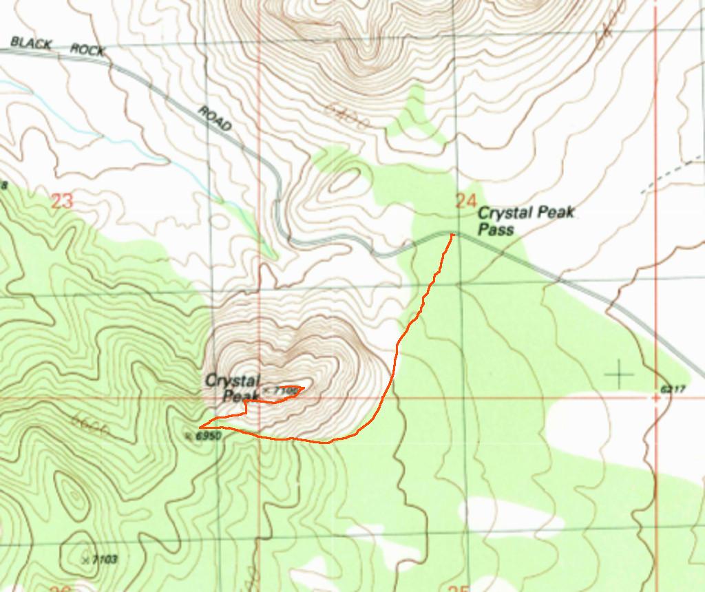
Here is a quick and dirty map of the route. This is not a GPS charted route; it's a best guess based on memory.