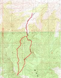
Lawson Cove
![/galleries/wah_wahs_2002/001_the_landmark_ponderosa_[Sat_Apr_13_2002].thumbnail.jpg](../galleries/wah_wahs_2002/001_the_landmark_ponderosa_[Sat_Apr_13_2002].thumbnail.jpg)
Getting There
Lawson Cove is a north-facing canyon, tucked into the east side of the Wah Wahs north of Wah Wah Summit. It looked cool on a USGS map, so I organized a trip there for the WMC back in April 2002. It worked out really well, even though only two people showed up. It turned out to be a very pretty area, with interesting rock formations, a forest of white fir, ponderosa and bristlecone, and a small scenic narrow canyon section.
I organized the trip again for the following year. I had great turn-out, but a monster snowstorm hit on the drive down from SLC and most folks ended up staying in a motel in Beaver. (I slept in the back of my truck in the snow at Wah Wah Summit, the original meeting place, in case anyone was crazy enough to drive there. Nobody actually showed up.) When we went to Lawson Cove, the snow was deep and soft; we managed to posthole up to the ridge, which was a valiant effort, and we turned around.
I returned in April 2014. As in 2002, the conditions were great, and only one person showed up for the hike. Oh well!
The easiest way to get to Lawson Cove from Salt Lake City is to take the Black Rock Road west from SR-257, 47 mi south of Delta. This is a very good dirt road, and you can generally just follow the better-looking road westward at each intersection. (The exception: at a fork south of Sevier Lake, bear left rather than following the equally-good-looking right fork to a salt factory.) You'll go about 27 mi to a junction with the Wah Wah Valley road. Turn south (left) here and drive about 4.8 mi to the Lawson Cove road, passing Lawson Cove Reservoir (usually dry) and crossing a low pass. The Lawson Cove road makes a hard west (right) turn and heads into a wide valley. The road gradually gets worse as you go west, with rocks and washouts. At about 7 mi, there is a junction with a road heading southwest into Lawson Cove Canyon. Go left here and drive up to the WSA boundary, if you can find the marker. The road is quite funky here, making abrupt turns and squeezing between trees. In 2014, we parked at UTM 0277246 4278094, but in retrospect, this was probably past the WSA boundary.
The Route
Regardless of where you parked on the dirt track, you'll continue down the track to the south. The track gets better defined as it climbs into the forest. Cliffs appear on the east side of the canyon.
It's a lovely green forest even though there is no surface water, with pinyons, junipers, white firs and ponderosas. Keep pushing up the canyon even after the road fades, until you can see the south wall. At this point, you should turn west up the slope.
The slope is fairly steep and it's often loose. Pick your way through the trees and around deadfall. There are a few cliff bands, like the one in the photo. Try to avoid drifting north, where the mountain-mahogany is more aggressive and the cliff bands are more prevalent.
You crest quite abruptly at a flattish summit ridge, bounded by cliffs on the west.
Turn south (left) and stroll over rolling ridges to the high point visible to the southwest. The map calls this bump Peak 8918 or Ranch Benchmark. It's easy walking through open forest.
At the summit, you encounter the final set of west-facing cliffs, which loom over Pine Valley. There are fine views out to the Indian Peak Range, Mountain Home Range and Snake Range. There are almost no signs of civilization; SR-21 is a tiny stripe in the desert, and you may be able to make out structures at the Forest Service's Desert Experimental Range along the road.
The forest on top is mostly bristlecones, with a few mountain-mahogany trees here and there. Some of the bristlecones are gorgeous, particularly the ones along the ridge to the north of the summit.
The return leg of the loop follows the bottom of the drainage to the northeast of the summit. There is some deadfall, but it's mostly easy walking.
You drop into a wonderful zone where white firs, ponderosas, bristlecones and pinyons mix together in a green but open forest. The deadfall and brush increases as you head down, but it's not very hard to find routes through the brush. The best routes are usually in or beside the wash.
The walls of the valley close in and form a gorge. There are rock spires on both sides. One side drainage has some very interesting minerals — I found a thumb-size transparent quartz crystal in the sand, although most of the quartz is in the form of jasper.
The gorge gets pretty and shady as it approaches a climax. There are a couple of very minor scrambles to climb down fallen boulders and small pour-offs. The valley opens out again, and after a while you reach the Lawson Cove track again. Turn north (left) to get back to your vehicle.
The main Lawson Cove road continues west past the turn-off for Lawson Cove Canyon, turning north to climb a ridge. You can drive out to the north toward Crystal Peak but the road is quite marginal and overgrown. You will want high clearance and you shouldn't care too much about your paint job. It's very slow going — it's actually faster to go east back out to the Wah Wah Valley road and north, even though that's many miles longer, because the road higher up is in such bad condition.
![/galleries/wah_wahs_2002/000_the_entrance_to_Lawson_Cove_[Sat_Apr_13_2002].thumbnail.jpg](../galleries/wah_wahs_2002/000_the_entrance_to_Lawson_Cove_[Sat_Apr_13_2002].thumbnail.jpg)
![/galleries/wah_wahs_2002/002_the_road_through_the_forest_[Sat_Apr_13_2002].thumbnail.jpg](../galleries/wah_wahs_2002/002_the_road_through_the_forest_[Sat_Apr_13_2002].thumbnail.jpg)
![/galleries/wah_wahs_2014/004_cliff_band_[Sat_Apr_19_2014].thumbnail.jpg](../galleries/wah_wahs_2014/004_cliff_band_[Sat_Apr_19_2014].thumbnail.jpg)
![/galleries/wah_wahs_2014/005_looking_south_to_the_summit_[Sat_Apr_19_2014].thumbnail.jpg](../galleries/wah_wahs_2014/005_looking_south_to_the_summit_[Sat_Apr_19_2014].thumbnail.jpg)
![/galleries/wah_wahs_2002/003_the_west-side_cliffs,_looking_south_[Sat_Apr_13_2002].thumbnail.jpg](../galleries/wah_wahs_2002/003_the_west-side_cliffs,_looking_south_[Sat_Apr_13_2002].thumbnail.jpg)
![/galleries/wah_wahs_2002/004_wiggly_bristlecones_[Sat_Apr_13_2002].thumbnail.jpg](../galleries/wah_wahs_2002/004_wiggly_bristlecones_[Sat_Apr_13_2002].thumbnail.jpg)
![/galleries/wah_wahs_2014/006_white_fir,_ponderosa_and_bristlecone_[Sat_Apr_19_2014].thumbnail.jpg](../galleries/wah_wahs_2014/006_white_fir,_ponderosa_and_bristlecone_[Sat_Apr_19_2014].thumbnail.jpg)
![/galleries/wah_wahs_2002/005_in_the_narrows_[Sat_Apr_13_2002].thumbnail.jpg](../galleries/wah_wahs_2002/005_in_the_narrows_[Sat_Apr_13_2002].thumbnail.jpg)
