Peak 9393 (Wah Wah Range High Point)
![/galleries/wah_wahs_1987/003_bristlecone_stump_on_the_summit_route_[Sat_Oct_03_1987].thumbnail.jpg](../galleries/wah_wahs_1987/003_bristlecone_stump_on_the_summit_route_[Sat_Oct_03_1987].jpg)
Getting There
I've hiked to the high point of the Wah Wahs exactly once, on a trip organized for the WMC by Aaron Jones way back in 1987. I didn't have a GPS and I didn't write down any directions, so my information is going to be pretty vague.
To get to the start of the hike, take SR-21 west from Milford over Wah Wah Summit into Pine Valley, about 35.5 mi. Look for a sign to Vance Spring and Lund; it's on the north (right) side of the road with arrows pointing to the south (left). Take the left onto this gravel road and go southwest 4.5 mi to the main Pine Valley Road. Head south (left) 5 mi and bear southeast (left) at an intersection to Pine Grove Canyon. Go about 7.5 mi southeast and east into Pine Grove Canyon and park near the mine workings north (left) of the road. (All of these directions are from Google Maps, not from my notes.)
I remember being surprised by a healthy ponderosa, and by the occasional aspen patches on north-facing slopes. There were a number of ruins of mine buildings in the canyon, and I don't know how much of that is still standing.
I distinctly remember that after the hike, we drove east out of the head of Pine Grove Canyon on a dirt road that was not well graded. Jerry Hatch decided to climb out of my VW Beetle on the hairiest section, after he got a fine view looking down a steep slope as the Beetle tilted precariously. It all worked out in the end, and we made it to the ghost town of Frisco to camp.
The Route
![/galleries/wah_wahs_1987/000_ore_sorter_in_Pine_Grove_Canyon_[Sat_Oct_03_1987].thumbnail.jpg](../galleries/wah_wahs_1987/000_ore_sorter_in_Pine_Grove_Canyon_[Sat_Oct_03_1987].jpg)
Back in 1987, there were still a number of mine buildings whose foundations could be identified, and this ore sorter was in good shape.
The ore sorter appears to be located at the Tasso mine, so I'm guessing that we started up the hill from that mine site. My recollection of the hike was that it was fairly steep and quite brushy, with mountain-mahogany catching on clothing and packs. I don't remember a use trail, but I suspect that there is one now, since this is a range high-point and high-pointing is a lot more common now.
From the map, it appears that you can walk north up a ridge from the mine to reach a main ridge that runs west from the peak.
![/galleries/wah_wahs_1987/001_Pine_Grove_Canyon_from_the_summit_[Sat_Oct_03_1987].thumbnail.jpg](../galleries/wah_wahs_1987/001_Pine_Grove_Canyon_from_the_summit_[Sat_Oct_03_1987].jpg)
Here is a view back into Pine Grove Canyon. You can see that the bottom of the canyon has been chained, and that there are mining roads scattered through the valley. My guess is that we came up the ridge in the far-right foreground.
The peak on the skyline to the right is Indian Peak.
![/galleries/wah_wahs_1987/002_WMCers_on_the_summit_[Sat_Oct_03_1987].thumbnail.jpg](../galleries/wah_wahs_1987/002_WMCers_on_the_summit_[Sat_Oct_03_1987].jpg)
Here is a photo from the summit. I recognize Jerry Hatch in the center, but not the other folks.
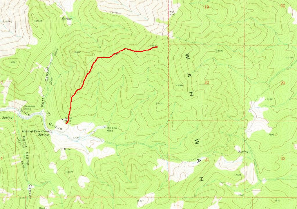
Here is a really wild-assed guess about the route that we took to the summit.
You can see the road that runs out of Pine Grove Canyon to the east. My distant recollection is that the fun part comes right after the saddle.