
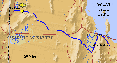
The blue line is the Hastings Trail, the yellow
dot is the location
of the camera and the yellow arrow is the camera direction.
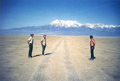
Photograph: Copyright © 1971 Roy D. Tea Made 5/1/71, near Donner Spring, Utah. Looking west. Here, from left to right are Bruce Bloomfield, Quinton Adair and Dan Miller, friends of Roy Tea who are interested in the trail. This mud flat is the last of the salt desert as emigrants descended from crossing Silver Island at Donner-Reed Pass and made the final push to Donner Spring. This photograph was made a couple of miles west of the pass and about seven miles from the water. Pilot Peak, 10,700 feet high and beacon for nearly 100 miles of travel, dominates the view. Donner Spring is a little beyond the far margin of the flat where trees can just be seen left of center. |
[ Return to Hastings Cutoff Exhibition ]
[ Return to Gallery ] [ Crossroads Home ]
Photographs may not be used without permission of their copyright owners.
Original content copyright ©
1997-2001 by
Utah Crossroads Chapter, Oregon-California Trails Association. All rights reserved.
Site design by Steven L. Berlin
E-mail regarding this site: Utah Crossroads
Webmaster
Revised: 10/25/04