
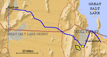
The blue line is the Hastings Trail, the yellow dot is the location
of the camera and the yellow arrow is the camera direction.
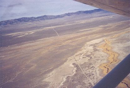
Photograph: Copyright © 1971 Roy D. Tea Made 1971, Skull Valley, Utah. This photograph was taken above Skull Valley several miles south of the previous one. Having proceeded south into Skull Valley far enough to skirt the wetlands, the Hastings Trail is seen here angling sharply back to the northwest as it leaves the area of Hope Wells. Hastings Pass through the Cedar Mountains is the low area in about the center of the skyline to the right of the trail's line. A tiny flow from Redlum Spring in the foothills of the Cedars was the only water known to emigrants between here and Donner Spring nearly 80 miles beyond. Beneath the airplane is about the place where Eliza P. Donner Houghton of the Donner Party describes her mother piecing together a note left by Hastings that appeared to have been shredded by birds: "2 days--2 nights--hard driving--cross--desert--reach water." (See Roy Tea's article on the Hastings Trail from Grantsville to Donner Spring in our Members' Pages section). |
[ Return to Hastings Cutoff Exhibition ]
[ Return to Gallery ] [ Crossroads Home ]
Photographs may not be used without permission of their copyright owners.
Original content copyright ©
1997-2001 by
Utah Crossroads Chapter, Oregon-California Trails Association. All rights reserved.
Site design by Steven L. Berlin
E-mail regarding this site: Utah Crossroads
Webmaster
Revised: 10/25/04