Noah's Ark
![/galleries/cedar_breaks_2014/007_the_ark_[Sun_Jul_6_10:21:25_MDT_2014].thumbnail.jpg](../galleries/cedar_breaks_2014/007_the_ark_[Sun_Jul_6_10:21:25_MDT_2014].thumbnail.jpg)
Getting There
The cliffy summit opposite Vermillion Castle to the south is called Noah's Ark. The hike is about twice as long as the Vermillion Castle hike, and it climbs much higher.
See the driving directions for Vermillion Castle to get to the Noah's Ark trailhead. The trail starts in the Five-Mile Picnic Area just west of the Vermillion Castle trailhead. There is a small sign for the Noah's Ark trailhead at the entrance to the picnic area.
The Route
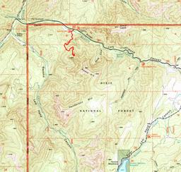
Go through the gate into the picnic area. Turn west (right) and pass a few picnic sites until the dirt road bends to the south (left) and crosses Bowery Creek. On the far side of the creek, turn east again (left) and look for the trail heading off to the south (right).
The trail winds through oak brush, pinyon and juniper, climbing fairly steadily to the south with a few switchbacks. Eventually the trail comes out on a bench and meets up with a faint old road. Follow the road southeast up the slope toward the cliffs.
The trail turns northeast into a draw and after a while, it begins to climb a series of switchbacks. Ponderosas rise above manzanita. The trail emerges on a ridge with a fine view down into Bowery Creek.
The trail switchbacks a short distance up this ridge, then heads south along a line of gray conglomerate cliffs.
At the south end of the cliffs, a draw runs steeply east into a bowl. The trail enters the draw and switchbacks up the north side next to the cliffs. The trail is steep and loose, with cobbles that have eroded out of the conglomerate. There are some fun towers and alcoves in this stretch.
To get around a cliff band, the trail strikes out to the south through white-fir, ponderosa and pinyon forest. Crags rise up through the forest.
After the climb, the trail eases its grade and heads north above the cliffs. It crosses below the next cliff band and descends slightly to a broad shelf.
There are amazing views in every direction. Off to the west you can see more pink cliffs and then the green irrigated fields west of Parowan. In the far distance, Indian Peak rises. At your feet, the conglomerate cliffs drop dizzyingly into the canyon.
Northeast up Bowery Canyon you can see the vertical cliff bands that run across the north face of Noah's Ark. On the skyline are the basalt cliffs of the Markagunt Plateau. Off to the north is the blazing red-pink bulk of Vermillion Castle.
This is the end of the trail. I didn't spot any use path heading higher on Noah's Ark. I suspect that you can reach the top of Noah's Ark with some careful route-finding, but I didn't check it out.
The Forest Service says that the Noah's Ark trail is 1.5 mi long.
Bowery Creek runs in First Left-Hand Fork Canyon (why not “Bowery Canyon”? go figure). I drove up the dirt road in Second Left-Hand Fork Canyon (Center Creek) and it looks just as cool as First Left-Hand Fork Canyon. The road starts out paved but soon becomes dirt with numerous washouts — 4WD is recommended but probably not required. The area looks like a great place to go exploring.
![/galleries/cedar_breaks_2014/008_the_way_up_[Sun_Jul_6_10:00:55_MDT_2014].thumbnail.jpg](../galleries/cedar_breaks_2014/008_the_way_up_[Sun_Jul_6_10:00:55_MDT_2014].thumbnail.jpg)
![/galleries/cedar_breaks_2014/009_steep_and_loose_[Sun_Jul_6_10:11:28_MDT_2014].thumbnail.jpg](../galleries/cedar_breaks_2014/009_steep_and_loose_[Sun_Jul_6_10:11:28_MDT_2014].thumbnail.jpg)
![/galleries/cedar_breaks_2014/010_crags_in_the_forest_[Sun_Jul_6_10:14:18_MDT_2014].thumbnail.jpg](../galleries/cedar_breaks_2014/010_crags_in_the_forest_[Sun_Jul_6_10:14:18_MDT_2014].thumbnail.jpg)
![/galleries/cedar_breaks_2014/012_the_shelf_[Sun_Jul_6_10:22:02_MDT_2014].thumbnail.jpg](../galleries/cedar_breaks_2014/012_the_shelf_[Sun_Jul_6_10:22:02_MDT_2014].thumbnail.jpg)
![/galleries/cedar_breaks_2014/011_the_north_wall_[Sun_Jul_6_10:21:38_MDT_2014].thumbnail.jpg](../galleries/cedar_breaks_2014/011_the_north_wall_[Sun_Jul_6_10:21:38_MDT_2014].thumbnail.jpg)
![/galleries/cedar_breaks_2014/013_it_gets_tough_from_here_[Sun_Jul_6_10:23:36_MDT_2014].thumbnail.jpg](../galleries/cedar_breaks_2014/013_it_gets_tough_from_here_[Sun_Jul_6_10:23:36_MDT_2014].thumbnail.jpg)
![/galleries/cedar_breaks_2014/014_lots_of_switchbacks_[Sun_Jul_6_10:48:52_MDT_2014].thumbnail.jpg](../galleries/cedar_breaks_2014/014_lots_of_switchbacks_[Sun_Jul_6_10:48:52_MDT_2014].thumbnail.jpg)
