
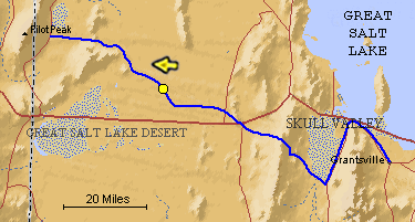
The blue line is the Hastings Trail, the yellow dot is the location
of the camera and the yellow arrow is the camera direction.
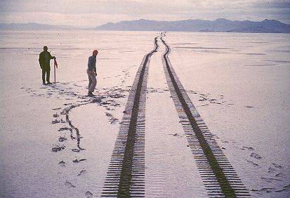
Photograph: Copyright © 1961 Roy D. Tea Made 10/61, Great Salt Lake Desert, Utah. View looking west. Hastings/Donner-Reed Trail runs from left center to upper right, between the two men. The trail is lighter in color because it has been compacted some by the wagons and animals, allowing a little more white salt to fill the slight depressions. Floating Island is at the right and at greater distance, stretching across the right two-thirds of the skyline, is Silver Island. Phil Marstella stands by a 2" X 2" stake he and professor Derle Thorpe of Utah State University (in the red cap) have just placed to mark the trail. The tracks were made by the Trackmaster. |
[ Return to Hastings Cutoff Exhibition ]
[ Return to Gallery ] [ Crossroads Home ]
Photographs may not be used without permission of their copyright owners.
Original content copyright ©
1997-2001 by
Utah Crossroads Chapter, Oregon-California Trails Association. All rights reserved.
Site design by Steven L. Berlin
E-mail regarding this site: Utah Crossroads
Webmaster
Revised: 10/25/04