![]()
Photograph Exhibition
The Hastings Trail* from
Grantsville, Utah to Donner Spring, Utah
Photographs by Roy D. Tea
![]()
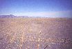
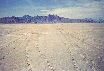
This exhibition illuminates many significant places along the Hastings Cutoff in the critical desert segment between what is now called Grantsville and Donner Spring, Utah, near the border with Nevada. The motivation for taking the cutoff or short-cut was its supposed time-savings in reaching California. In the event, this portion of the Hastings Trail was treacherous and proved costly to many who passed this way.
All but two of the photographs were made by Roy and are a small part of his extensive collection taken over several decades of frequent visits to these remote areas. A quick check of the pictures' dates reveals his interest in the old emigrant trails goes back a long way. Several of the photographs in the collection were made in 1961! Changes to the road over recent decades make documentary evidence of its previous condition, as many of the photographs here provide, especially valuable to historians and preservationists. The terrain over this portion of the Hastings Cutoff is mostly level with only the pass through the Cedar Mountains and topping the Grayback Hills presenting difficult grades for the draft animals. But the 60 mile stretch across the wastes of the Great Salt Lake Desert through sand dunes and mud flats was another matter. The mud flats, playas from the old bottoms of the Great Salt Lake and ancient Lake Bonneville, both in the trails era as today, can be firm and easy pulling in one place, soft and extremely taxing in another and here and there, impossible quagmires. The flats look deceptively solid, but water is often only a few inches below the surface. Should a vehicle, whether a wagon drawn by oxen or a modern four-wheel-drive, break through the thin dry crust in these wet areas, the deeper its wheels go the softer the muck and in moments the conveyance can be settled to its hubs in the sticky mire. Both 150 years ago and today this common occurrence is a serious emergency with property and even life at stake. That wagons stuck in this unique mud could not be salvaged and had to be abandoned where they lay is no mystery to the modern visitor to the area. An almost always harrowing corridor for the pioneers, to this day, no one may safely venture here without adequate equipment and preparation and few people do. The synergistic problems of no water, no feed and treacherous terrain impoverished many who made the passage and were forced to leave wagons and property on the desert. Some lost animals to exhaustion, thirst and sometimes to the difficulties of driving loose cattle through the night on a forced march to distant water. Of the many tribulations experienced by the Donner Party, their losses here were especially devastating, greatly contributing to their peril on the journey ahead. Though the numbers of people who crossed this portion of the Hastings Trail is often under-appreciated, it seems certain that more than one thousand people and several hundred wagons took the road in the five years from 1846 to 1850, most of these travelers driven by the urgencies of the California gold rush. After that time the dangerous route fell into almost complete disuse. * N.B. This portion of the Hastings Cutoff is variously referred to as the Hastings Trail, Hastings Road, Donner Trail, Donner Road, Donner-Reed Trail or Road, etc. Although all these terms are acceptable, Mr. Tea prefers Hastings Cutoff or Hastings Trail for this segment of the way.
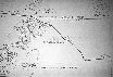
Approximate Route of
To see captions and full-size versions of the pictures, click on a picture "thumbnail". |
| 1. SE towards Hastings or Twenty Wells Grantsville, UT |
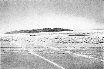
 |
2. The Trail Toward Timpie Point Tooele Valley, UT |
 |
| 3. Looking SW Timpie Point, Skull Valley, UT |
 |
4. Looking NW Skull Valley, UT |
 |
| 5. Looking NW Cedar Mountains, Skull Valley, UT |
 |
6. Hastings Pass Cedar Mountains, Skull Valley, UT |
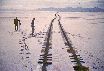
 |
| 7. Hastings Pass Cedar Mountains, Skull Valley, UT |
 |
8. Swale, W Side, Cedar Mountains, UT |
 |
| 9. Entering the Desert W of Grayback Hills, UT |
 |
10. Approaching the Dunes, East Side, Great Salt Desert, UT |
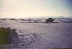
 |
| 11. Approaching The Big Bend, Historical Photograph, 1936 Great Salt Desert, UT |
 |
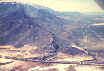
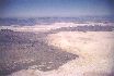
12. The Big Bend from the Air Great Salt Desert, UT |
 |
| 13. The Big Bend Great Salt Desert, UT |
 |
14. The Big Bend Great Salt Desert, UT |
 |
| 15. Pristine Trail, 1961 Great Salt Desert, UT |
 |
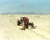
16. Marking the Road, 1961 Great Salt Desert, UT |
 |
| 17. The Stake Still Stands 25 Years Later Great Salt Desert, UT |
 |
18. Abandoned Wagon Historical Photograph, 1930 Great Salt Desert, UT |
 |
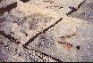
| 19. Main Archeology Site Great Salt Desert, UT |
 |
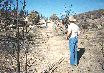
20. Another View of the Main Archeology Site Great Salt Desert, UT |
 |
| 21. Wagon Mound Archeological Excavation Great Salt Desert, UT |
 |
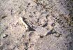
22. Sharp, 140 Year-Old Wagon Ruts Great Salt Desert, UT |
 |
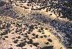
| 23. East of Silver Island Great Salt Desert, UT |
 |
24. Hastings Road NE of Floating Island Great Salt Desert, UT |
 |
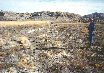
| 25. Ox Bones? Great Salt Desert, UT |
 |
26. The Professor's Map Great Salt Desert, UT |
 |
| 27. Donner-Reed Pass Silver Island - Crater Island, UT |
 |
28. Donner-Reed Pass Silver Island, UT |
 |
| 29. Nearing Donner Spring Great Salt Desert, UT |
 |
30. Aerial View of the Saving Waters Donner Spring, UT |
 |
Home | Activities
| Contact Us | Forum | Lectures
| Join Us | Links
| Members | News | Newsletter
Picture Gallery | Publications | Trails
| Trail Marking | Members' Pages | Search |
OCTA
Chapters | OCTA
Original content copyright ©
1997-2007 by
Utah Crossroads Chapter, Oregon-California Trails Association. All rights reserved.
Trademarks, Service Marks and Logos are property of their respective owners.
Site design by Steve. Berlin
E-mail regarding this site: Utah
Crossroads Webmaster
Revised: 12 Apr 2007

