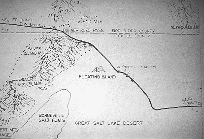
Photograph: Copyright © 1997 Roy D. Tea This map was created under the supervision of Professor Derle Thorpe of the Utah State University engineering faculty who recorded the distances and bearings during what was termed the Mirage Expedition in 1962. Other members of the party were Professors David Miller and Web of the University of Utah. These three followed the trail from the Knolls flight strip, just west of the Grayback Hills to Donner Spring. Note the Big Bend. |
[ Return to Hastings Cutoff Exhibition ]
[ Return to Gallery ] [ Crossroads Home ]
Photographs may not be used without permission of their copyright owners.
Original content copyright ©
1997-2001 by
Utah Crossroads Chapter, Oregon-California Trails Association. All rights reserved.
Site design by Steven L. Berlin
E-mail regarding this site: Utah Crossroads
Webmaster
Revised: 10/25/04