
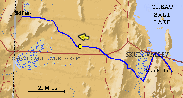
The blue line is the Hastings Trail, the yellow dot is the location
of the camera and the yellow arrow is the camera direction.
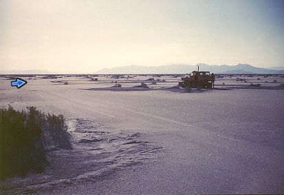
Photograph: Copyright © 1961 Roy D. Tea Made 10/61, Great Salt Lake Desert, Utah. View looking west. Donner-Reed Trail at the "Big Bend." The trail runs from lower right to left center, then curves at the blue arrow to the right behind the trackmaster. The arrow points in the approximate direction the trail takes at this point which is northwest. Floating Island is the closer dark mountain just to the right of the Trackmaster. The mountain behind Floating Island and above the Trackmaster is Silver Island. Pilot Peak is the faint mountain on the distant skyline just left of the vehicle. |
[ Return to Hastings Cutoff Exhibition ]
[ Return to Gallery ] [ Crossroads Home ]
Photographs may not be used without permission of their copyright owners.
Original content copyright ©
1997-2001 by
Utah Crossroads Chapter, Oregon-California Trails Association. All rights reserved.
Site design by Steven L. Berlin
E-mail regarding this site: Utah Crossroads
Webmaster
Revised: 10/25/04