
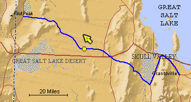
The blue line is the Hastings Trail, the yellow dot is the location
of the camera and the yellow arrow is the camera direction.
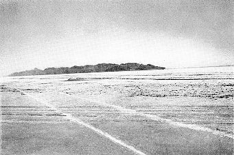
Photograph: Copyright © 1936-50, Dr. Walter M. Stookey Made: 9/36 Great Salt Lake Desert, Utah This photograph is from Fatal Decision, The Tragic Story of the Donner Party, Dr. Walter M. Stookey, Salt Lake City: 1950. Dr. Stookey, a Grantsville, Utah physician had an avid interest in the Donner Party and the Hastings Trail across the salt desert. In his book he captions the picture, which appears on page 103, as follows:
The view is northwest toward Floating and Silver Islands. Floating Island is the dark object at the top of the plain in the center of the picture. Here the trail proceeds west before reaching the "Big Bend" where it turns northwest toward Silver Island Point. This view shows the remarkable preservation of surface indications of the tracks. |
[ Return to Hastings Cutoff Exhibition ]
[ Return to Gallery ] [ Crossroads Home ]
Photographs may not be used without permission of their copyright owners.
Original content copyright ©
1997-2001 by
Utah Crossroads Chapter, Oregon-California Trails Association. All rights reserved.
Site design by Steven L. Berlin
E-mail regarding this site: Utah Crossroads
Webmaster
Revised: 10/25/04