
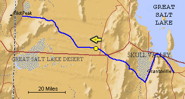
The blue line is the Hastings Trail, the yellow dot is the location
of the camera and the yellow arrow is the camera direction..
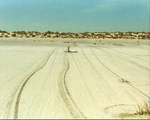
Photograph: Copyright © 1987 Roy D. Tea Made 9/23/87 Great Salt Desert, Utah. The east side of the Great Salt Lake Desert is marked by sand dunes as well as stretches of flats. Softer ground to the north in this area prevented the emigrants from taking a direct route toward Pilot Peak, at the foot of which, they knew they would find water. Here the trail approaches an area of dunes after passing through a small depression. To climb up on the dunes, the trail curves to the right but then straightens and proceeds nearly due west again. A 6" aluminum pipe can be seen near the center of the photograph which has just been placed to mark the trail by Dan Miller Jr. and Roy Tea. |
[ Return to Hastings Cutoff Exhibition ]
[ Return to Gallery ] [ Crossroads Home ]
Photographs may not be used without permission of their copyright owners.
Original content copyright ©
1997-2001 by
Utah Crossroads Chapter, Oregon-California Trails Association. All rights reserved.
Site design by Steven L. Berlin
E-mail regarding this site: Utah Crossroads
Webmaster
Revised: 10/25/04