![]()
Marking Historic Trails
![]()
| The heart of OCTA's historic trail preservation
program is the identification and marking of historically significant 19th century
emigrant wagon trails. Beginning in 1982, the year OCTA was founded, an on-going effort
has and is being made to map and mark three National Historic Trails and their alternate
routes—the Oregon National Historic Trail, the Mormon Pioneer National Historic Trail,
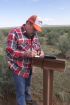
and the California National Historic Trail. White Carsonite posts (visible
in the accompanying photographs) are used with
identifying logo and trail name decals. The California-Nevada Chapter and
the Utah Crossroads Chapter have also placed, and are placing, heavy rail
posts at selected sites and segments. Trail marking posts are placed on trail segments and at
historic trail sites that have been identified and verified by historians and
cartographers who have studied and mapped the trail routes. Trail routes go through private, state owned and federal public lands. Permission to place the OCTA trail markers must be obtained from the owners and agencies who own or are responsible for management of public lands. OCTA and the state chapters work with land owners, state and federal agencies and other historic trail organizations to identify, map, mark and protect the last remaining vestiges of these historic wagon trails and historic trail sites. Utah Crossroads works closely with the Long Distance Trails Office of the National Parks Service, the regional offices of the Bureau of land Management, the Utah State Department of Natural Resources Division of Parks and Recreation, and the Utah Historic Trails Consortium. Owners of private and corporate property on whose land historic trail routes cross are advised and consulted when pristine trail evidence such as wagon wheel ruts, swales, and trail landmarks are threatened by cultivation, corporate exploration or development. The white Carsonite posts and decals used in the trail marking program are purchased with OCTA's Trail Committee funds, or are financed by the National Park Service under a Challenge Cost-Share Program agreement. The Cost-Share Program provides NPS funds for the purchase of trail mapping and marking materials for approved projects. OCTA's share of approved projects is met through volunteer labor hours and mileage. Utah Crossroads has mapped and marked the California Trail alternate routes in Utah—the Hastings Cutoff and Hensley's Salt Lake Cutoff. The Mormon Pioneer Trail and California Trail west of Fort Bridger to the Salt Lake Valley has been marked with white Carsonite posts by the Utah Crossroads and Wyoming chapters of OCTA. As a result of ongoing trail research by historians and trail enthusiasts, the work of mapping and marking historic trails and their variants is a constant process. Regrettably too, trail markers and interpretive panels are often damaged or destroyed by vandalism. As a result, marking trails will never be a completed project. OCTA volunteers give generously of their time, talents and resources to map, mark and preserve historic wagon trails and trail sites. -Al Mulder |
|
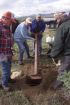
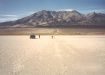
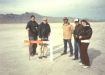
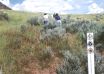
Getting out and marking the trails is both a lot of effort and a lot of fun. Usually done on a Saturday, plenty of preparations go into being ready to place the right monument in the right place. Here are a few photographs from recent trail marking activities. The locations are remote and you can see that it can take a lot of hands to do the job right. Join us some time for a day of trail marking and come away tired but satisfied you have helped preserve a priceless part of America's heritage. To see captions and full-sized versions of the pictures, click on a picture "thumbnail". |
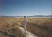
| Hastings Cutoff Near Aragonite, UT |
 |
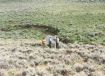
Placing Carsonite Coyote Creek, WY |
 |
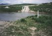
| Rocky Ford Malad River, UT |
 |
Placing Post Lakepoint, UT |
 |
| Placing Post Near Grantsville, UT |
 |
GPS Near Grantsville, UT |
 |
| Lunch Timpie Point, UT |
 |
Salt Desert Near Donner Spring, UT |
 |
| Placing Marker Salt Desert, UT |
 |
In the Ruts East Canyon, UT |
 |
Home | Activities
| Contact Us | Forum | Lectures
| Join Us | Links
| Members | News | Newsletter
Picture Gallery | Publications | Trails
| Trail Marking | Members' Pages | Search |
OCTA
Chapters | OCTA
Original content copyright ©
1997-2007 by
Utah Crossroads Chapter, Oregon-California Trails Association. All rights reserved.
Trademarks, Service Marks and Logos are property of their respective owners.
Site design by Steve. Berlin
E-mail regarding this site: Utah
Crossroads Webmaster
Revised: 12 Apr 2007
