
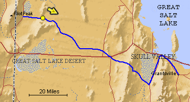
The blue line is the Hastings Trail, the yellow dot is the location
of the camera and the yellow arrow is the camera direction.
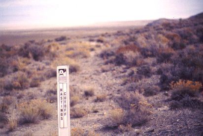
Photograph: Copyright © 1995 Roy D. Tea Made 1995, Silver Island, Great Salt Desert, Utah. The trail kept to the flats and rounded a rocky point before ascending a low saddle between Silver Island and Crater Island. Although separate toward the end of the Lake Bonneville era, these two islands today are one continuous landform. This is the OCTA Carsonite marker on the saddle, now called Donner-Reed Pass. The view is southeast toward the mud flats of the salt desert. In 1929, Charles Kelly interviewed an eighty-year-old rancher named Eugene Munsee who 50 years before had homesteaded the land around a spring 2 miles south of Donner Spring. Among other interesting facts, Mr.Munsee told Kelly that water could be found on Silver Island in two places including a cave not far from the trail. In extensive investigations of the island searching for road-building material in the 1960s, Roy Tea did not discover any large water sources but did find a cave on the west side of the island and south of the trail where a few drops of water dripped from its ceiling. |
[ Return to Hastings Cutoff Exhibition ]
[ Return to Gallery ] [ Crossroads Home ]
Photographs may not be used without permission of their copyright owners.
Original content copyright ©
1997-2001 by
Utah Crossroads Chapter, Oregon-California Trails Association. All rights reserved.
Site design by Steven L. Berlin
E-mail regarding this site: Utah Crossroads
Webmaster
Revised: 10/25/04