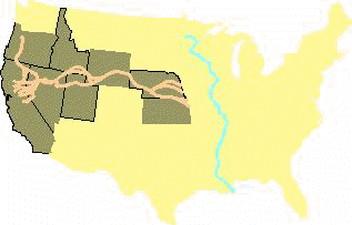
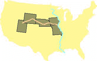
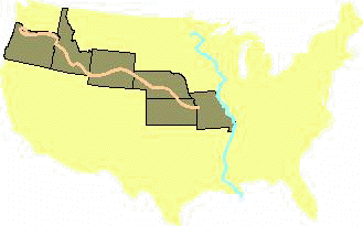
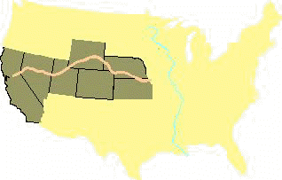
Approximate route of the Spanish Trail.
Historical Outline of the Spanish Trail
by Steven K. Madsen
(Information on the author)
The Spanish Trail, an 1120-mile trade and emigration route, bridged the greater part of
the American Southwest during the mid-nineteenth century and linked Santa Fe, New Mexico,
with Los Angeles, California.
John C. Frémont was the first to use the term "Spanish Trail" to describe
the trade route linking New Mexico and California. He recorded the name in his official
report and on his famous map of the 1844 expedition. Other mapmakers lifted the trail from
Frémont's map and added the word "Old." In post-trail years, government
surveyors (including the 1859 Macomb military expedition) who followed the route also
added the word "old" to the name. The trail has Spanish roots, but it was opened
during the Mexican period (1821-1848) of the Southwest.
Its Spanish beginnings:
The concept of the trail arose during the Spanish colonial period of the American
West. To defend the Spanish frontier from British, French, and Russian incursions, Spain
sought to link its two most settled northern regions -- the upper Rio Grande in New Mexico
and the California coast.
Hostile tribes, however, blocked the straight path across Arizona that would tie
together the northern frontier settlements. Arizona's long, waterless stretches and the
cliffbound Colorado River presented other obstacles to direct east-west travel.
In 1776, Franciscan priests Dominguez and Escalante explored a route from New Mexico to
the Great Basin. Another Spaniard, Francisco Garces, explored the area from the Colorado
River to the California settlements. Exploration was needed, however, to connect the
Dominguez-Escalante route with the Garces route. Later Spanish trading parties made forays
into the Great Basin to trade with Indians living along Utah's Wasatch Front, but no
Spanish trails from New Mexico's heartland reached the Pacific Coast. In 1821, Spanish
dominion over the Southwest passed to the Republic of Mexico.
Opening the trail:
Hispanic traders revived attempts to reach the settlements of California only
after learning of the travels of fur trapper Jedediah Smith. Smith made two overland treks
(1826 and 1827) from the mountain wilderness to southern California, virtually connecting
the routes of Garces and Dominguez-Escalante.
By 1829, Smith's routes of travel were generally known in New Mexico. That year, the
New Mexican merchant, Antonio Armijo, launched the first trading venture to California
from New Mexico, following the extreme eastern and western segments of the Spanish Trail.
In 1830-1831 the American mountain men William Wolfskill and George C. Yount led a fur
trading party over the general course of the trail, from Santa Fe to Los Angeles. (In the
party were New Mexican merchants who acquired horses in California and drove them back to
New Mexico the following spring.) By 1840, the Spanish Trail had been laid out along the
present course as we know it.
Primary use:
Woolen goods and pack animals were the principal trade items on the Spanish Trail. New
Mexico was sheep country -- woolen textiles were its chief product of export. Raw wool and
locally-woven fabrics were packed on mules and carried to the Spanish-built settlements of
southern California. Merchants left the upper Rio Grande Valley in the early fall to avoid
the winter conditions in the interior mountains. It took trail riders two and one-half
months to complete the overland journey.
In California, woolen products were exchanged for horses and mules, which were driven
back to New Mexico. The return trip was made in the spring to avoid the high water in the
Green and Colorado rivers. The great livestock herds of southern California were in big
demand in the interior West. Upwards of two thousand animals or more were driven over the
trail. Pack animals were needed along the Santa Fe Trail to the Missouri frontier. (On
reaching Santa Fe, many Spanish Trail horses and mules were herded up the Santa Fe Trail
to the outfitting centers on the California, Oregon, and Mormon trails. These animals in
turn conveyed many of the early pioneer settlers to the interior West.) Horse dealers also
found a ready market among Native Americans and American fur trappers in the mountain
wilderness.
En route, Ute Indians exacted tribute from trading parties on the trail. As
accomplished riders, the Utes were always in the market for horses. They generally
maintained friendly relations with the caravans and engaged in limited commerce with the
Hispanic merchants.
The Southern Paiutes, occupying southwestern Utah and Nevada, were often victimized by
passing trade caravans. Since they were not equestrians they were at a disadvantage in
dealing with mounted traders who often enslaved their women and children. It became a
sideline business of the yearly caravans. Slave traffickers sold their captives in the New
Mexico and California settlements.
Although Hispanic traders were the primary users of the trail, several mountain men
traveled it, including Miles Goodyear, Thomas L. "Peg-leg" Smith, Old Bill
Williams, Antoine Robidoux, and Joseph Walker. Several trapping parties used the northern
branch of the trail that originated at Taos, New Mexico, and ran north through the San
Luis Valley of Colorado before reaching the main Spanish Trail near Green River, Utah.
In 1844, John C. Frémont's exploring party, guided by trappers Kit Carson and Thomas
Fitzpatrick, followed the western section of the Spanish Trail and helped map its course.
Fur trappers, traders, and Indians often stole horses from California's ranchos and
missions, using the Spanish Trail as their escape route. Horse stealing became a
flourishing business, prompting government officials to inspect the annual caravans before
they departed the Los Angeles basin.
Close of the trail:
From 1829 to 1848 the Spanish Trail passed through territory that belonged to the
Republic of Mexico. In 1848, at the close of the Mexican War, Mexico deeded the Southwest
to the United States. After the Mexican Cession, many overlanders chose more direct routes
to the north and south. Those who chose a southern path could follow trails that had been
carved out across Arizona by U.S. soldiers during the war. Thus, caravan traffic over the
Spanish Trail soon came to an end.
Post-trail use:
Mormon settlers developed the trail's western half for wagon traffic between Salt
Lake City and Los Angeles. Known as the Southern Route, or Mormon Road, it became an
important corridor to the Pacific.
Mormon guide Jefferson Hunt led Forty-Niners to the California gold fields over the
western half of the Spanish Trail (part of the group followed a cutoff route that led into
Death Valley, where some of them perished.)
Segments of the Spanish Trail were used by Texas cattlemen who herded their livestock
to the mining districts of southwestern Colorado in the post Civil War era.
Route of the trail:
The Spanish Trail ran 1,120 miles from Santa Fe to Los Angeles. It looped
northward through central Utah to avoid the deep river gorges of the Colorado River.
The trail began in the Santa Fe plaza. It followed up the Rio Grande Valley then veered
in a northwesterly direction through northern New Mexico. It crossed the Continental
Divide before reaching the San Juan River in Colorado.
The pack route continued across Colorado, passing near Mesa Verde, and entered Utah
east of Monticello.
From the Utah border, the trail passed by today's Canyonlands and Arches national parks
and crossed the Colorado and Green rivers. It then cut across the southern part of the
Great Basin to Mountain Meadows. (A tragic massacre of overland emigrants occurred here in
post-trail days.)
From the rim of the basin, the trail reentered the drainage of the Colorado River. It
crossed the northwestern corner of Arizona then continued to the meadows of Las Vegas
after a 55-mile waterless desert stretch.
Beyond Las Vegas, the trail crossed the Mojave Desert to the California coast, by way
of Cajon Pass. Mission San Gabriel, nine miles from Los Angeles, was a supply point for
early travelers. The plaza in Los Angeles was the end of the trail for many of the
California-bound trading parties.
Steven K. Madsen is author of In
Search of of the Spanish Trail: Santa Fe to Los Angeles, 1829-1848 (Salt Lake City:
Gibbs Smith, Publisher, 1994 - available mailorder from the OCTA Bookstore). He delivered the
12th Annual Juanita Brooks Lecture, sponsored by Dixie College, in 1995. Madsen received
his bachelor's degree from the University of Utah and his master's degree from Brigham
Young University. He is the former historian of Washington, D.C.'s National Independence
Day Festival & Parade. He is a high school history teacher in Salt Lake City (and
listed in Who's Who Among America's Teachers, 2nd ed.). Madsen is also the author
of "The Spanish Trail" in the automobile guide, Trailing the Pioneers.
He has authored several articles for the publication, Spanish Traces. Spanish
Traces is issued by the Old Spanish Trail Association, P.O. Box 510, Monte Vista, CO
81144. Return to: The Spanish Trail