
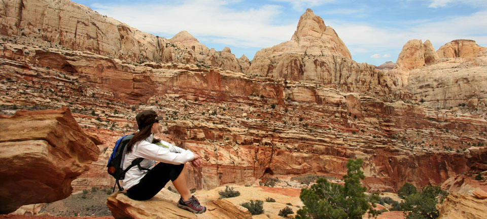
Capitol Reef National Park Activities
The summer season at Capitol Reef National Park will kick-off in late May with activities,
presentations and extended visitor center hours. The Visitor Center will be open from 8:00 AM to 6:00 PM daily beginning late May. The historic Gifford Farmhouse is open every day from 8:00 AM until 5:00 PM. A regular schedule of daily ranger-led interpretive services and programs will begin in late May and will continue throughout the summer. The historic Fruita schoolhouse will be open from 10:00 to 11:30 AM. Geology talks will be offered in the visitor center at 10:50 AM and 1:50 PM. Ranger programs will be given at the petroglyph panel on Highway 24 at 3:00 PM. A ranger-guided walk will be available daily. Check at Visitor Center for schedule. Programs at the campground amphitheater will be held nightly. Times and topics will be posted at the Visitor Center and on campground bulletin boards. Special programs at the Gifford House and the Ripple Rock Nature Center are planned throughout the summer season. All programs and events are free of charge and open to the general public. For more information, call the park visitor center at 435-425-3791 extension 111.
For Kids at Capitol Reef National Park
Visit the Ripple Rock Nature Center located a short walk or drive from the Visitor Center. It is open May 25, 2010 through September 6, 2010. Check Park bulletin boards for facility
hours and scheduled activities. Interview a ranger, map an ancient earthquake, or get your feet wet watching waterbugs! Become a Junior Ranger or a Junior Geologist, or grab a Family Fun Pack for a closer look around. More information is available at the Visitor Center.
Check ranger Activity Schedules posted in all park bulletin boards for specific program and facility times and locations, or call the visitor center at 425-3791extension 111.
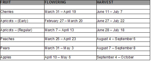
When the fruit trees are in bloom
While driving through Capitol Reef National Park, you will noticethe variety of fruit trees in bloom. These trees consist of cherry, apricot, peach, pear, and apple. Plan to return to Capitol Reef National Park this Summer and Fall to enjoy the harvest of these fruits. The historic Fruita orchards contain over 2700 fruit bearing trees. Pick and eat all you want for free in the orchards, or take some home for a nominal fee. The orchards open to picking as optimal ripeness is reached. Refer to the chart for approximate times for flowering (which is great for photos) and you-pick harvest.
Harvest Time
Fruit picking is a great way for the whole family to enjoy Capitol Reef National Park. The historic Fruita orchards contain over 2,700 fruit bearing trees. Pick and eat all you want for free in the orchards or take some home for a nominal fee. The orchards open to picking as optimal ripeness is reached. Refer to the chart for approximate time for harvest.
Geology
The Waterpocket Fold defines Capitol Reef National Park. A nearly 100-mile long warp in the
Earth's crust, the Waterpocket Fold is a classic monocline: a regional fold with one very steep side in an area of otherwise nearly horizontal layers. A monocline is a "step-up" in Waterpocket Fold the rock layers. The layers on the west side of the Waterpocket Fold have been lifted more than 7000 feet higher than the layers on the east. Major folds are almost always associated with underlying faults. The Waterpocket Fold formed between 50 and 70 million years ago when a major mountain building event in western North America, the Laramide Orogeny, reactivated an ancient buried fault. When the fault moved, the overlying rock layers were draped above the fault and formed a monocline. More recent uplift of the entire Colorado Plateau and the resulting erosion has exposed this fold at the surface only within the last 15 to 20 million years. The name Waterpocket Fold reflects this ongoing erosion of the rock layers. "Waterpockets" are basins that form in many of the sandstone layers as they are eroded by water. These basins are common throughout the fold, thus giving it the name "Waterpocket Fold". Erosion of the tilted rock layers continues today forming colorful cliffs, massive domes, soaring spires, stark monoliths, twisting canyons, and graceful arches.
Slot Canyons
Slot canyons or “narrows” are fairly common throughout Capitol Reef Country. They sometimes begin very high up in the cliffs and flow out to the lower valleys or sometimes stay relatively level and cut completely through the standing rock. Winding and twisting through solid sandstone, these canyons could fit a car or barely fit a person standing sideways.
It is easy to forget that these beautiful narrow passageways are extremely dangerous. Flash
floods from miles away send muddy red water shooting down the slot at incredible speeds.
When hiking the narrows, always pay attention to the weather, and leave notice of which canyon you are hiking and when you should return.
Capitol Reef Minimum Impact Practices:
• Know where you are allowed to camp.
• Tread lightly when traveling and leave no trace of your camping.
• Help keep Capitol Reef Country clean. If you pack it in – pack it out. Clean up after less thoughtful visitors.
• Camp away from isolated water sources.
• Teach children not to chase or interact with wildlife.
• Keep pets under control and know where they are not allowed.
• Leave historic sites, ruins, artifacts and rock art undisturbed for the future. Please report violations.
• Be respectful when you are in the back country
Capitol Reef Terms and Definitions
Here are some terms and definitions you may encounter as you travel through Capitol Reef Country.
Mesa – a flat-topped hill with steep sides.
Plateau – a level expanse of elevated land.
Butte – An isolated, steep hill.
Monument – the remaining hard rock center of an eroded Butte.
Bluff – a steep head land, river bank or cliff.
Bench – a long gradual series of hills.
Flat – an open level area, usually at higher altitude.
Draw – a shallow canyon or drainage.
Wash – the dry bed of a stream.
Canyon – a narrow steep drainage.
Arroyo – a gully eroded by a stream.
Gulch – an arroyo.
Gorge – a large canyon.
Slot canyon – a very narrow canyon.
Petroglyph – rock art that is chipped or carved on a rock face.
Pictograph – rock art that is painted on a rock face.
Arch – a span of rock formed by the erosion of softer surrounding rock layers.
Natural bridge – an arch formed by and spanning a water course.
Night Skies
Did you know two-thirds of the U.S. population and one-fifth of the world population can no longer see the Milky Way in the night sky! Capitol Reef National Park is considered to have one of if not the darkest night sky of any national park in the United States.
High Altitude Sickness
Anyone coming from lower altitudes to 6000 feet or more may complain of headache, unusual fatigue, nausea, loss of appetite, difficulty sleeping, and/or shortness of breath. This may be altitude sickness. The best treatment is: do not go up until the symptoms go down. Take it easy. Drink plenty of water. Avoid caffeine and alcohol. If symptoms persist consult a doctor and get to a lower altitude
> Capitol Reef Information
> Capitol Reef History
> Capitol Reef More
